IMAGES TAKEN NEAR TO
Holmes Chapel Road, KNUTSFORD, WA16 9LB
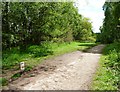
Introduction
This page details the photographs taken nearby to Holmes Chapel Road, WA16 9LB by members of the Geograph project.
The Geograph project started in 2005 with the aim of publishing, organising and preserving representative images for every square kilometre of Great Britain, Ireland and the Isle of Man.

There are currently over 7.5m images from over14,400 individuals and you can help contribute to the project by visiting https://www.geograph.org.uk
Image Map
Images are licensed for reuse under creativecommons.org/licenses/by-sa/2.0
Notes
- Clicking on the map will re-center to the selected point.
- The higher the marker number, the further away the image location is from the centre of the postcode.
Image Listing (45 Images Found)
Images are licensed for reuse under creativecommons.org/licenses/by-sa/2.0
Image
Details
Distance
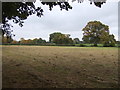
1
Shakerley Wood, at Shakerley Mere
Shakerley Mere was once a quarry, where sand was excavated to make coloured glass. When production ended in the early 1960s, the quarry filled with water and became a mere. It is now a popular leisure and wildlife site, run by the council.
Image: © Christine Johnstone
Taken: 13 May 2012
0.04 miles
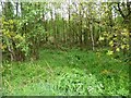
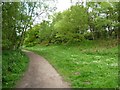
2
Footpath alongside the woodland, Shakerley Mere
Shakerley Mere was once a quarry, where sand was excavated to make coloured glass. When production ended in the early 1960s, the quarry filled with water and became a mere. It is now a popular leisure and wildlife site, run by the council.
Image: © Christine Johnstone
Taken: 13 May 2012
0.05 miles
3
Mallards perched on a notice, Shakerley Mere
Shakerley Mere was once a quarry, where sand was excavated to make coloured glass. When production ended in the early 1960s, the quarry filled with water and became a mere. It is now a popular leisure and wildlife site, run by the council.
Image: © Christine Johnstone
Taken: 13 May 2012
0.07 miles
4
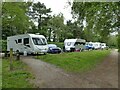
Travellers at Shakerley Mere
A group of travellers' caravans occupying part of the main car park.
Image: © Stephen Craven
Taken: 26 Jun 2021
0.07 miles
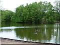
5
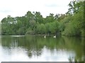
Swans on Shakerley Mere
Shakerley Mere was once a quarry, where sand was excavated to make coloured glass. When production ended in the early 1960s, the quarry filled with water and became a mere. It is now a popular leisure and wildlife site, run by the council.
Image: © Christine Johnstone
Taken: 13 May 2012
0.08 miles
6
Southern car park, Shakerley Mere
Shakerley Mere was once a quarry, where sand was excavated to make coloured glass. When production ended in the early 1960s, the quarry filled with water and became a mere. It is now a popular leisure and wildlife site, run by the council.
Image: © Christine Johnstone
Taken: 13 May 2012
0.08 miles
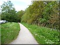
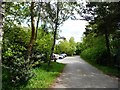
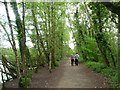
7
Footpath at southern corner of Shakerley Mere
Shakerley Mere was once a quarry, where sand was excavated to make coloured glass. When production ended in the early 1960s, the quarry filled with water and became a mere. It is now a popular leisure and wildlife site, run by the council.
Image: © Christine Johnstone
Taken: 13 May 2012
0.09 miles
8
Pipeline marker, Shakerley Mere
With a warning that this is a 'no dig zone'. Shakerley Mere was once a quarry, where sand was excavated to make coloured glass. When production ended in the early 1960s, the quarry filled with water and became a mere. It is now a popular leisure and wildlife site, run by the council.
Image: © Christine Johnstone
Taken: 13 May 2012
0.11 miles
9
Walking the dogs at Shakerley Mere
Shakerley Mere was once a quarry, where sand was excavated to make coloured glass. When production ended in the early 1960s, the quarry filled with water and became a mere. It is now a popular leisure and wildlife site, run by the council.
Image: © Christine Johnstone
Taken: 13 May 2012
0.12 miles