IMAGES TAKEN NEAR TO
Toft Road, KNUTSFORD, WA16 9ER
Introduction
This page details the photographs taken nearby to Toft Road, WA16 9ER by members of the Geograph project.
The Geograph project started in 2005 with the aim of publishing, organising and preserving representative images for every square kilometre of Great Britain, Ireland and the Isle of Man.

There are currently over 7.5m images from over14,400 individuals and you can help contribute to the project by visiting https://www.geograph.org.uk
Image Map
Images are licensed for reuse under creativecommons.org/licenses/by-sa/2.0
Notes
- Clicking on the map will re-center to the selected point.
- The higher the marker number, the further away the image location is from the centre of the postcode.
Image Listing (20 Images Found)
Images are licensed for reuse under creativecommons.org/licenses/by-sa/2.0
Image
Details
Distance
2
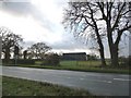
Empty field, empty road
Looking towards farm buildings at Seven Sisters farm, from across the A50
Image: © Christine Johnstone
Taken: 6 Dec 2009
0.05 miles
3
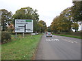
Holmes Chapel Road (A50)
Heading north west towards Knutsford.
Image: © JThomas
Taken: 29 Oct 2016
0.07 miles
4
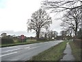
The A50, on a wet Sunday morning, near Seven Sisters Lane.
Red signs warn of accident rates all along the A50 south of Knutsford.
Image: © Christine Johnstone
Taken: 6 Dec 2009
0.07 miles
5
Seven Sisters Lane, looking away from the A50
Image: © Christine Johnstone
Taken: 6 Dec 2009
0.08 miles
6
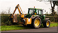
Holmes Chapel Road
Hedge trimming on the A50, Holmes Chapel Road. I have this chap to thank for a puncture!
Image: © Peter McDermott
Taken: 13 Sep 2014
0.09 miles
8
Patch of nettles, at the junction of Seven Sisters Lane and the A50
Image: © Christine Johnstone
Taken: 6 Dec 2009
0.10 miles
9
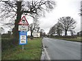
Road signs, northbound on the A50
Just south of the junction of the A50 and the B5081
Image: © Christine Johnstone
Taken: 6 Dec 2009
0.10 miles
10
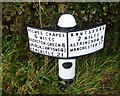
Old Milepost by the A50, south of Knutsford
Metal post with attached metal plate by the A50, in parish of Toft (Macclesfield District), Holmes Chapel Road, 100m South of Seven Sisters Farm, opposite lay-by on verge, on East side of road. Cheshire open book casting, erected by the Cranage & Warrington turnpike trust in the 19th century.
Inscription reads:-
: HOLMES CHAPEL / 6 MILES / BRERETON.GREEN 8 / CHURCH.LAWTON 14½ / NEWCASTLE 21 : : KNUTSFORD / 2 MILES / ALTRINCHAM 9 / MANCHESTER 17 :
Maker:-
: W H SMITH & CO / MAKERS / WHITCHURCH :
Grade II listed.
List Entry Number: 1139290 https://historicengland.org.uk/listing/the-list/list-entry/1139290
Milestone Society National ID: CH_HCKF06
Image: © J Higgins
Taken: 16 Sep 2011
0.11 miles