IMAGES TAKEN NEAR TO
Toft Road, KNUTSFORD, WA16 9EH
Introduction
This page details the photographs taken nearby to Toft Road, WA16 9EH by members of the Geograph project.
The Geograph project started in 2005 with the aim of publishing, organising and preserving representative images for every square kilometre of Great Britain, Ireland and the Isle of Man.

There are currently over 7.5m images from over14,400 individuals and you can help contribute to the project by visiting https://www.geograph.org.uk
Image Map
Images are licensed for reuse under creativecommons.org/licenses/by-sa/2.0
Notes
- Clicking on the map will re-center to the selected point.
- The higher the marker number, the further away the image location is from the centre of the postcode.
Image Listing (13 Images Found)
Images are licensed for reuse under creativecommons.org/licenses/by-sa/2.0
Image
Details
Distance
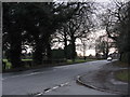
1
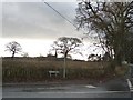
Junction of Gough's Lane and Toft Road
Image: © Christine Johnstone
Taken: 6 Dec 2009
0.07 miles
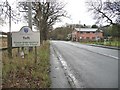
2
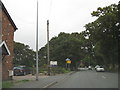
A50 at Toft Smithy
The nameboard for entering Knutsford appears just above the yellow sign.
Image: © Peter Whatley
Taken: 28 Aug 2008
0.10 miles
4
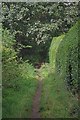
Footpath to Leycester Rd
A footpath through the leafy suburbs of Knutsford
Image: © Glyn Baker
Taken: 21 Sep 2013
0.12 miles
6
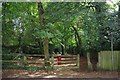
Footpath Through Windmill Wood, Gough's Lane
This path will take you to Chelford Rd through Windmill Wood
Image: © Glyn Baker
Taken: 21 Sep 2013
0.13 miles
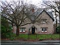
8
Knutsford - Toft Road, looking south from Beggarmans Lane
Image: © Peter Whatley
Taken: 19 Jan 2012
0.16 miles
9

Legh Road (Lovat drive on right)
Looking towards south west towards Goughs lane
Image: © Ian Warburton
Taken: 18 Nov 2002
0.19 miles
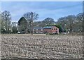
10
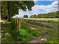
Field beside Sandfield Wood
Footpath to left leads around Toft Hall to Lower Peover.
Image: © Alan Pickup
Taken: 13 May 2020
0.24 miles