IMAGES TAKEN NEAR TO
Toft Road, KNUTSFORD, WA16 9DY
Introduction
This page details the photographs taken nearby to Toft Road, WA16 9DY by members of the Geograph project.
The Geograph project started in 2005 with the aim of publishing, organising and preserving representative images for every square kilometre of Great Britain, Ireland and the Isle of Man.

There are currently over 7.5m images from over14,400 individuals and you can help contribute to the project by visiting https://www.geograph.org.uk
Image Map
Images are licensed for reuse under creativecommons.org/licenses/by-sa/2.0
Notes
- Clicking on the map will re-center to the selected point.
- The higher the marker number, the further away the image location is from the centre of the postcode.
Image Listing (139 Images Found)
Images are licensed for reuse under creativecommons.org/licenses/by-sa/2.0
Image
Details
Distance
1
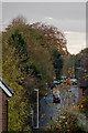
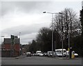
The A537 approaching the junction with the A50
Image: © Roger A Smith
Taken: 7 Nov 2016
0.04 miles
2
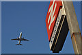
A Boeing 737-8K5 (G-FDZF) over Knutsford approaching Manchester airport
Image: © Roger A Smith
Taken: 26 Aug 2013
0.05 miles
3
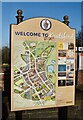
Around Knutsford (1)
Civic guide, outside the station
Image: © Anthony O'Neil
Taken: 22 Feb 2022
0.05 miles
4
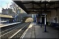
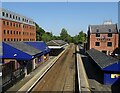
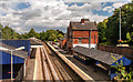
On the Platform
Knutsford Station, looking west
Image: © Anthony O'Neil
Taken: 22 Feb 2022
0.05 miles
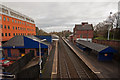
10
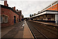
Knutsford Railway Station
Knutsford Railway Station seen from Toft Road.
Image: © Peter McDermott
Taken: 11 Aug 2014
0.07 miles