IMAGES TAKEN NEAR TO
Ashworth Park, KNUTSFORD, WA16 9DE
Introduction
This page details the photographs taken nearby to Ashworth Park, WA16 9DE by members of the Geograph project.
The Geograph project started in 2005 with the aim of publishing, organising and preserving representative images for every square kilometre of Great Britain, Ireland and the Isle of Man.

There are currently over 7.5m images from over14,400 individuals and you can help contribute to the project by visiting https://www.geograph.org.uk
Image Map
Images are licensed for reuse under creativecommons.org/licenses/by-sa/2.0
Notes
- Clicking on the map will re-center to the selected point.
- The higher the marker number, the further away the image location is from the centre of the postcode.
Image Listing (4 Images Found)
Images are licensed for reuse under creativecommons.org/licenses/by-sa/2.0
Image
Details
Distance
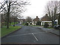
2
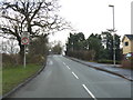
Knutsford - railway bridge on Blackhill Lane
Image: © Peter Whatley
Taken: 19 Jan 2012
0.11 miles
3
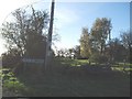
Black Hill Lane
Blackhill Farm just visible to right
Image: © Ian Warburton
Taken: 25 Nov 2005
0.22 miles
4
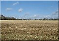
View over farmland
Towards Knutsford town
Image: © Anthony O'Neil
Taken: 22 Feb 2022
0.25 miles