IMAGES TAKEN NEAR TO
Moss Lane, KNUTSFORD, WA16 8SW
Introduction
This page details the photographs taken nearby to Moss Lane, WA16 8SW by members of the Geograph project.
The Geograph project started in 2005 with the aim of publishing, organising and preserving representative images for every square kilometre of Great Britain, Ireland and the Isle of Man.

There are currently over 7.5m images from over14,400 individuals and you can help contribute to the project by visiting https://www.geograph.org.uk
Image Map
Images are licensed for reuse under creativecommons.org/licenses/by-sa/2.0
Notes
- Clicking on the map will re-center to the selected point.
- The higher the marker number, the further away the image location is from the centre of the postcode.
Image Listing (3 Images Found)
Images are licensed for reuse under creativecommons.org/licenses/by-sa/2.0
Image
Details
Distance
1
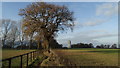
View NW to water tower at Bowden Bank Farm near over Peover
Image: © Colin Park
Taken: 7 Dec 2016
0.10 miles
2
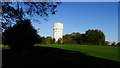
Water tower by Bowden Bank Farm, Over Peover
Image: © Colin Park
Taken: 29 Oct 2018
0.10 miles
3
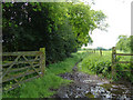
Bridleway near Over Peover
A bridleway leaves Moss Lane towards Bowden Bank Farm and a large water tower. Just past the tower it heads SW alongside Merrydale Golf Club towards Over Peover. At this point, from where the photo is taken, its character changes into a muddy track suitable only for horses that revel on heavy ground.
Image: © michael ely
Taken: 30 May 2006
0.17 miles