IMAGES TAKEN NEAR TO
Ash Lane, KNUTSFORD, WA16 8RQ
Introduction
This page details the photographs taken nearby to Ash Lane, WA16 8RQ by members of the Geograph project.
The Geograph project started in 2005 with the aim of publishing, organising and preserving representative images for every square kilometre of Great Britain, Ireland and the Isle of Man.

There are currently over 7.5m images from over14,400 individuals and you can help contribute to the project by visiting https://www.geograph.org.uk
Image Map
Images are licensed for reuse under creativecommons.org/licenses/by-sa/2.0
Notes
- Clicking on the map will re-center to the selected point.
- The higher the marker number, the further away the image location is from the centre of the postcode.
Image Listing (8 Images Found)
Images are licensed for reuse under creativecommons.org/licenses/by-sa/2.0
Image
Details
Distance
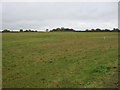
1
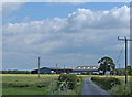
Ash Farm, near Knutsford
Looking SE down the bridleway-cum-farm track. Photo taken from near the junction with Seven Sisters Lane.
Image: © michael ely
Taken: 30 May 2006
0.06 miles
2
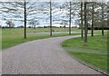
Pond
Grounds of Ash House (Ash Lane Farm)
Image: © Anthony O'Neil
Taken: 23 Feb 2022
0.08 miles
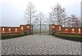
6
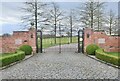
Entrance Gates
'Ash House', off Seven Sisters Lane
Image: © Anthony O'Neil
Taken: 23 Feb 2022
0.13 miles
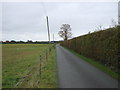
7
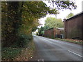
Seven Sisters Lane
Looking north east near Moss Bank Farm.
Image: © JThomas
Taken: 29 Oct 2016
0.17 miles
8
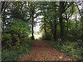
Track into Moss Wood
Off Seven Sisters Lane.
Image: © JThomas
Taken: 29 Oct 2016
0.19 miles