IMAGES TAKEN NEAR TO
Greenacre Close, KNUTSFORD, WA16 8NL
Introduction
This page details the photographs taken nearby to Greenacre Close, WA16 8NL by members of the Geograph project.
The Geograph project started in 2005 with the aim of publishing, organising and preserving representative images for every square kilometre of Great Britain, Ireland and the Isle of Man.

There are currently over 7.5m images from over14,400 individuals and you can help contribute to the project by visiting https://www.geograph.org.uk
Image Map
Images are licensed for reuse under creativecommons.org/licenses/by-sa/2.0
Notes
- Clicking on the map will re-center to the selected point.
- The higher the marker number, the further away the image location is from the centre of the postcode.
Image Listing (14 Images Found)
Images are licensed for reuse under creativecommons.org/licenses/by-sa/2.0
Image
Details
Distance
3
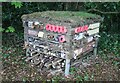
Bug hotel on Higher Town Green
Bug hotel recently installed in the conservation area by Knutsford Town Council
Image: © Alan Pickup
Taken: 5 May 2021
0.13 miles
4
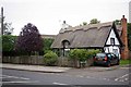
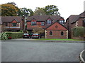
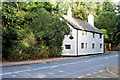
Over Place, Knutsford
This cottage stands on the junction of the A537 Chelford Rd and Over Place
Image: © Glyn Baker
Taken: 21 Sep 2013
0.13 miles
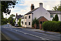
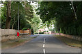
8
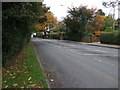
Chelford Road (A537), Knutsford
Looking north west.
Image: © JThomas
Taken: 29 Oct 2016
0.16 miles
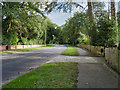
9
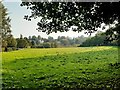
View over Sanctuary Moor from Toft Road
Houses on Legh Road in the background.
Image: © Alan Pickup
Taken: 22 Sep 2020
0.22 miles