IMAGES TAKEN NEAR TO
Church Mews, KNUTSFORD, WA16 8HX
Introduction
This page details the photographs taken nearby to Church Mews, WA16 8HX by members of the Geograph project.
The Geograph project started in 2005 with the aim of publishing, organising and preserving representative images for every square kilometre of Great Britain, Ireland and the Isle of Man.

There are currently over 7.5m images from over14,400 individuals and you can help contribute to the project by visiting https://www.geograph.org.uk
Image Map
Images are licensed for reuse under creativecommons.org/licenses/by-sa/2.0
Notes
- Clicking on the map will re-center to the selected point.
- The higher the marker number, the further away the image location is from the centre of the postcode.
Image Listing (65 Images Found)
Images are licensed for reuse under creativecommons.org/licenses/by-sa/2.0
Image
Details
Distance
1
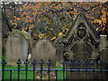
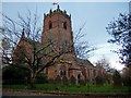
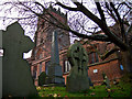
Part of the grave yard of St. Cross Church, Knutsford
Image: © Roger A Smith
Taken: 6 Nov 2016
0.06 miles
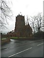
3
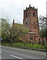
St Cross, Knutsford
Parish Church on Mobberley Road
Image: © Eirian Evans
Taken: 25 May 2016
0.06 miles
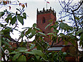
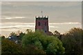
7
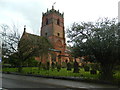
St Cross Church, Knutsford
A Grade II listed building.
Image: © John Lord
Taken: 31 Dec 2012
0.06 miles
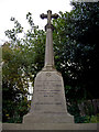
10
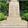
Over Knutsford War Memorial Dedication
On the front face of Image
IN GRATEFUL REMEMBRANCE
OF THE MEN
CONNECTED WITH THIS PARISH
WHO DIED
FOR FREEDOM AND HONOUR
IN THE GREAT WAR
1914-1918
THEIR NAME LIVETH FOR EVERMORE
Image: © David Dixon
Taken: 5 Sep 2020
0.07 miles