IMAGES TAKEN NEAR TO
Pinfold Lane, KNUTSFORD, WA16 7SW
Introduction
This page details the photographs taken nearby to Pinfold Lane, WA16 7SW by members of the Geograph project.
The Geograph project started in 2005 with the aim of publishing, organising and preserving representative images for every square kilometre of Great Britain, Ireland and the Isle of Man.

There are currently over 7.5m images from over14,400 individuals and you can help contribute to the project by visiting https://www.geograph.org.uk
Image Map
Images are licensed for reuse under creativecommons.org/licenses/by-sa/2.0
Notes
- Clicking on the map will re-center to the selected point.
- The higher the marker number, the further away the image location is from the centre of the postcode.
Image Listing (7 Images Found)
Images are licensed for reuse under creativecommons.org/licenses/by-sa/2.0
Image
Details
Distance
1
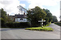
Junction of Marthall, Pedley and Pinfold Lanes
Directions but no distances are given on the standard Cheshire County Council fingerpost which may possibly pre-date the cottage behind which displays a plaque dated 1914.
Image: © Peter Turner
Taken: 3 Oct 2012
0.01 miles
2
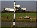
Direction Sign - Signpost near Rycroft Farm, Marthall parish
Pawn finial - 3 arms; Cheshire CCC octagonal in parish of Marthall (Macclesfield District), on a grass triangle in the centre of the junction of Pedley Lane, Pinfold Lane and Marthall Lane near Ryecroft Farm.
To be surveyed
Milestone Society National ID: CH_SJ7977
Image: © C Marcus
Taken: Unknown
0.02 miles
5
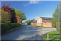
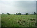
Marthall Lane
Ryecroft Farm at entrance to Mountpleasant Farm drive.
Image: © Peter Turner
Taken: 3 Oct 2012
0.19 miles
6
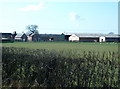
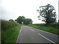
Ryecroft Farm near Ollerton, Cheshire
Image: © Anthony O'Neil
Taken: 22 Mar 2011
0.20 miles
7
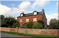
Fir Tree Farm, Marthall Lane
The fir tree seems long gone but this sturdy and capacious Cheshire farmhouse abides.
Image: © Peter Turner
Taken: 3 Oct 2012
0.24 miles