IMAGES TAKEN NEAR TO
Sandlebridge Lane, KNUTSFORD, WA16 7SB
Introduction
This page details the photographs taken nearby to Sandlebridge Lane, WA16 7SB by members of the Geograph project.
The Geograph project started in 2005 with the aim of publishing, organising and preserving representative images for every square kilometre of Great Britain, Ireland and the Isle of Man.

There are currently over 7.5m images from over14,400 individuals and you can help contribute to the project by visiting https://www.geograph.org.uk
Image Map
Images are licensed for reuse under creativecommons.org/licenses/by-sa/2.0
Notes
- Clicking on the map will re-center to the selected point.
- The higher the marker number, the further away the image location is from the centre of the postcode.
Image Listing (17 Images Found)
Images are licensed for reuse under creativecommons.org/licenses/by-sa/2.0
Image
Details
Distance
1
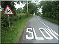
Sandle Bridge Lane, Marthall
Heading north east.
Image: © JThomas
Taken: 11 Jun 2016
0.02 miles
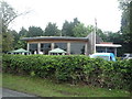
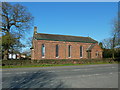
4
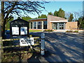
Ollerton & Marthall Village Hall, Sandlebridge Lane
Image: © Anthony O'Neil
Taken: 22 Mar 2011
0.10 miles
6
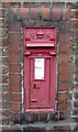
Victorian postbox on Sandlebridge Lane, Marthall
Postbox No. WA16 22.
See Image] for context.
Image: © JThomas
Taken: 11 Jun 2016
0.15 miles
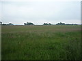
7
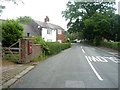
Sandlebridge Lane, Marthall
Showing position of Postbox No. WA16 22.
See Image] for postbox.
Image: © JThomas
Taken: 11 Jun 2016
0.15 miles
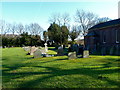
8
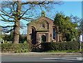
All Saints Parish Church, Sandlebridge Lane
Image: © Anthony O'Neil
Taken: 22 Mar 2011
0.16 miles
9
All Saints Church, Marthall, Cheshire
Image: © Anthony O'Neil
Taken: 22 Mar 2011
0.16 miles