IMAGES TAKEN NEAR TO
Slade Lane, KNUTSFORD, WA16 7QN
Introduction
This page details the photographs taken nearby to Slade Lane, WA16 7QN by members of the Geograph project.
The Geograph project started in 2005 with the aim of publishing, organising and preserving representative images for every square kilometre of Great Britain, Ireland and the Isle of Man.

There are currently over 7.5m images from over14,400 individuals and you can help contribute to the project by visiting https://www.geograph.org.uk
Image Map
Images are licensed for reuse under creativecommons.org/licenses/by-sa/2.0
Notes
- Clicking on the map will re-center to the selected point.
- The higher the marker number, the further away the image location is from the centre of the postcode.
Image Listing (31 Images Found)
Images are licensed for reuse under creativecommons.org/licenses/by-sa/2.0
Image
Details
Distance
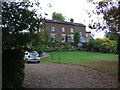
1
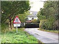
Road Narrows
Turning off Hobcroft Lane to the left at Greenbank takes one down a narrowing, winding lane, as this sign warns.
Image: © Roger May
Taken: 15 Nov 2005
0.02 miles
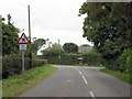
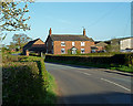
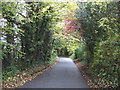
2
Approaching the bend in Hobcroft Lane, Mobberley
Image: © Anthony O'Neil
Taken: 8 Apr 2011
0.04 miles
3
Approaching Mobberley Station Turning, Hobcroft Lane
Image: © Peter Whatley
Taken: 17 Sep 2009
0.05 miles
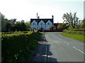
5
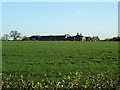
Greenbank Farm from Small Lane, Mobberley
Image: © Anthony O'Neil
Taken: 8 Apr 2011
0.07 miles
9
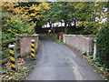
Narrow bridge on Slade Lane
Over Mobberley Brook.
Image: © JThomas
Taken: 29 Oct 2016
0.17 miles