IMAGES TAKEN NEAR TO
Woodend Lane, KNUTSFORD, WA16 7LZ
Introduction
This page details the photographs taken nearby to Woodend Lane, WA16 7LZ by members of the Geograph project.
The Geograph project started in 2005 with the aim of publishing, organising and preserving representative images for every square kilometre of Great Britain, Ireland and the Isle of Man.

There are currently over 7.5m images from over14,400 individuals and you can help contribute to the project by visiting https://www.geograph.org.uk
Image Map
Images are licensed for reuse under creativecommons.org/licenses/by-sa/2.0
Notes
- Clicking on the map will re-center to the selected point.
- The higher the marker number, the further away the image location is from the centre of the postcode.
Image Listing (14 Images Found)
Images are licensed for reuse under creativecommons.org/licenses/by-sa/2.0
Image
Details
Distance
1
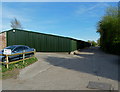
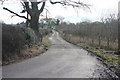
Somewhat larger than the average garden shed !
And not much encouragement to explore any further at the termination of Woodend Lane.
Image: © Anthony O'Neil
Taken: 6 Apr 2011
0.03 miles
2
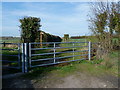
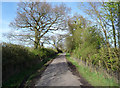
North Cheshire Way - beyond the end of Woodend Lane
A glimpse of Manchester Airport to the left.
Image: © Anthony O'Neil
Taken: 6 Apr 2011
0.04 miles
3
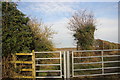
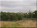
Woodend Lane end
Glimpsed through the break in the hedge the runway at Ringway (the original name of Manchester International Airport).
Image: © Peter Turner
Taken: 12 Jan 2013
0.05 miles
4
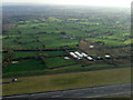
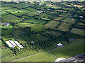
Woodend farm from the air
The south runway at Manchester Airport is visible at the bottom of the photo.
Image: © Thomas Nugent
Taken: 10 Nov 2014
0.13 miles
5
Bollin House Farm driveway
With Oak Farm buildings visible behind the near tree.
Image: © Peter Turner
Taken: 12 Jan 2013
0.13 miles
6
Woodend Lane
Once the depths of the Cheshire countryside, now only a few hundred metres from planes taking off at Manchester Airport.
Image: © Anthony O'Neil
Taken: 6 Apr 2011
0.13 miles
7
Manchester Airport from the air
Part of Runway 23L and industrial premises on Woodend Lane can be seen.
Image: © Thomas Nugent
Taken: 6 Jul 2020
0.13 miles
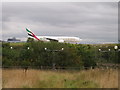
8
Cleared for takeoff
Photo taken from footpath NW end of ILS (Instrument Landing System) compound. Aircraft shown at the threshold of runway 1 with the River Bollin down amongst the trees.
Image: © Ian Warburton
Taken: 10 Sep 2005
0.18 miles
9
Taxiing to take off
Taken from footpath NW of ILS (Instrument Landing System) compound. Aircraft shown approaching the threshold of runway 1.
Image: © Ian Warburton
Taken: 10 Sep 2005
0.18 miles
10
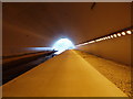
River Bollin Tunnel under Runway 2, Manchester Airport
Image: © Ian Warburton
Taken: 20 Nov 2005
0.18 miles