IMAGES TAKEN NEAR TO
Burleyhurst Lane, KNUTSFORD, WA16 7LP
Introduction
This page details the photographs taken nearby to Burleyhurst Lane, WA16 7LP by members of the Geograph project.
The Geograph project started in 2005 with the aim of publishing, organising and preserving representative images for every square kilometre of Great Britain, Ireland and the Isle of Man.

There are currently over 7.5m images from over14,400 individuals and you can help contribute to the project by visiting https://www.geograph.org.uk
Image Map
Images are licensed for reuse under creativecommons.org/licenses/by-sa/2.0
Notes
- Clicking on the map will re-center to the selected point.
- The higher the marker number, the further away the image location is from the centre of the postcode.
Image Listing (12 Images Found)
Images are licensed for reuse under creativecommons.org/licenses/by-sa/2.0
Image
Details
Distance

2
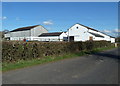
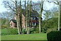
Outbuildings at Benkeyhurst Farm, Mobberley, Cheshire
Image: © Anthony O'Neil
Taken: 22 Mar 2011
0.04 miles
3
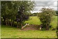
Burleyhurst Farm
Bridge carrying a footpath across Sugar Brook at Burleyhurst Farm.
Image: © Peter McDermott
Taken: 16 Aug 2014
0.06 miles
4
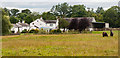
Benkeyhurst Farm near Mobberley, Cheshire
Image: © Anthony O'Neil
Taken: 22 Mar 2011
0.07 miles
6
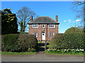
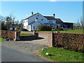
Detached house on Burleyhurst Lane, Mobberely
Image: © Anthony O'Neil
Taken: 22 Mar 2011
0.08 miles
7
Hollin House, off Davenport Lane, near Mobberley
Image: © Anthony O'Neil
Taken: 6 Apr 2011
0.13 miles
8

Derelict Garage near Knolls Green, Cheshire
Image: © Anthony O'Neil
Taken: 22 Mar 2011
0.15 miles
9
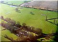
Davenport Lane, Mobberley, from the air
Taken from a plane just after take-off from Manchester Airport.
Image: © Mike Pennington
Taken: 30 Mar 2016
0.18 miles
10
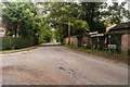
Holt Gardens
Junction of Blakely Lane and Davenport Lane at Holt Gardens.
Image: © Peter McDermott
Taken: 16 Aug 2014
0.22 miles