IMAGES TAKEN NEAR TO
Paddock Hill, KNUTSFORD, WA16 7DE
Introduction
This page details the photographs taken nearby to Paddock Hill, WA16 7DE by members of the Geograph project.
The Geograph project started in 2005 with the aim of publishing, organising and preserving representative images for every square kilometre of Great Britain, Ireland and the Isle of Man.

There are currently over 7.5m images from over14,400 individuals and you can help contribute to the project by visiting https://www.geograph.org.uk
Image Map
Images are licensed for reuse under creativecommons.org/licenses/by-sa/2.0
Notes
- Clicking on the map will re-center to the selected point.
- The higher the marker number, the further away the image location is from the centre of the postcode.
Image Listing (8 Images Found)
Images are licensed for reuse under creativecommons.org/licenses/by-sa/2.0
Image
Details
Distance
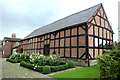
2
Barlow House Farm, near Wilmslow, Cheshire
Image: © Anthony O'Neil
Taken: 27 Jan 2011
0.02 miles

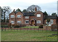
4
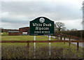
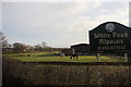
Alpaca farm, near Paddockhill, Cheshire
Image: © Anthony O'Neil
Taken: 27 Jan 2011
0.14 miles
5
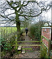
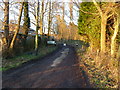
Public footpath, towards Row of Trees, Wilmslow, Cheshire
Image: © Anthony O'Neil
Taken: 27 Jan 2011
0.15 miles
8

Plough and Flail pub/restaurant car park entrance
A John Willy Lees house newly rejuvenated and serving good grub and ale.
Image: © Peter Turner
Taken: 5 Jan 2013
0.22 miles