IMAGES TAKEN NEAR TO
Moss Lane, KNUTSFORD, WA16 7BY
Introduction
This page details the photographs taken nearby to Moss Lane, WA16 7BY by members of the Geograph project.
The Geograph project started in 2005 with the aim of publishing, organising and preserving representative images for every square kilometre of Great Britain, Ireland and the Isle of Man.

There are currently over 7.5m images from over14,400 individuals and you can help contribute to the project by visiting https://www.geograph.org.uk
Image Map
Images are licensed for reuse under creativecommons.org/licenses/by-sa/2.0
Notes
- Clicking on the map will re-center to the selected point.
- The higher the marker number, the further away the image location is from the centre of the postcode.
Image Listing (6 Images Found)
Images are licensed for reuse under creativecommons.org/licenses/by-sa/2.0
Image
Details
Distance
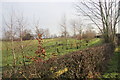
1
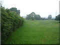
Grazing and hedgerow, Paddockhill
Off Paddockhill Lane.
Image: © JThomas
Taken: 11 Jun 2016
0.19 miles
2
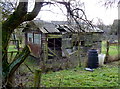
Shed on its last legs at Ivy House Farm, Mobberley
Image: © Anthony O'Neil
Taken: 27 Jan 2011
0.19 miles
4
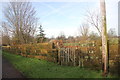
Quaker Graveyard, Graveyard Lane
At the end of Graveyard Lane, the graveyard. I understand Image, that denied burial in other burial grounds the local Quakers established their own some 4/500 years ago, and that visitors from 'all over the world' come here, presumably to view their antecedents' gravestones.
Image: © Peter Turner
Taken: 5 Jan 2013
0.23 miles
5
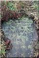
Gravestone in the Quaker graveyard
Clearly bearing the date 1682 due to overgrowth it is not certain whether the incumbent lived in Hale about 5miles distant or Carrington some miles beyond.
Image: © Peter Turner
Taken: 5 Jan 2013
0.23 miles
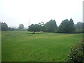
6
Green/Woodland burial ground
The preceding owner of Graveyard Farm Image had been a funeral director and had developed this area as a green burial ground. The name of the farm preceded this activity however.
Image: © Peter Turner
Taken: 5 Jan 2013
0.24 miles