IMAGES TAKEN NEAR TO
Moss Lane, KNUTSFORD, WA16 7BP
Introduction
This page details the photographs taken nearby to Moss Lane, WA16 7BP by members of the Geograph project.
The Geograph project started in 2005 with the aim of publishing, organising and preserving representative images for every square kilometre of Great Britain, Ireland and the Isle of Man.

There are currently over 7.5m images from over14,400 individuals and you can help contribute to the project by visiting https://www.geograph.org.uk
Image Map
Images are licensed for reuse under creativecommons.org/licenses/by-sa/2.0
Notes
- Clicking on the map will re-center to the selected point.
- The higher the marker number, the further away the image location is from the centre of the postcode.
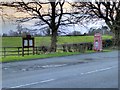
Image Listing (5 Images Found)
Images are licensed for reuse under creativecommons.org/licenses/by-sa/2.0
Image
Details
Distance
1
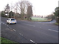
Knutsford Road/Moss lane junction Mobberley
B5085 heading left towards Knutsford.
Image: © Peter Turner
Taken: 13 Jan 2012
0.22 miles
4
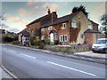
Former Sunday School Buildings, Knutsford Road
A plaque on the wall (Image]) indicates that this was formerly the Joseph Wood Memorial Sunday School. The plaque is dated 1901.
Image: © David Dixon
Taken: 3 Mar 2015
0.24 miles
5
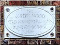
Joseph Wood Memorial Plaque
Plaque on the wall of the former Joseph Wood Memorial Sunday School Image Dated 1901.
Image: © David Dixon
Taken: 3 Mar 2015
0.25 miles