IMAGES TAKEN NEAR TO
Noahs Ark Lane, KNUTSFORD, WA16 7AX
Introduction
This page details the photographs taken nearby to Noahs Ark Lane, WA16 7AX by members of the Geograph project.
The Geograph project started in 2005 with the aim of publishing, organising and preserving representative images for every square kilometre of Great Britain, Ireland and the Isle of Man.

There are currently over 7.5m images from over14,400 individuals and you can help contribute to the project by visiting https://www.geograph.org.uk
Image Map
Images are licensed for reuse under creativecommons.org/licenses/by-sa/2.0
Notes
- Clicking on the map will re-center to the selected point.
- The higher the marker number, the further away the image location is from the centre of the postcode.
Image Listing (4 Images Found)
Images are licensed for reuse under creativecommons.org/licenses/by-sa/2.0
Image
Details
Distance
1
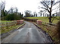
Bridge (crossing Mobberley Brook) on Noah's Ark Lane
Image: © Anthony O'Neil
Taken: 27 Jan 2011
0.08 miles
2
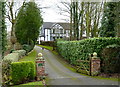
Noahwood House, Noah's Ark Lane, Mobberley
Image: © Anthony O'Neil
Taken: 27 Jan 2011
0.08 miles
3
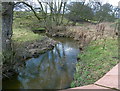
Mobberley Brook, at Noah's Ark Lane, Cheshire
Image: © Anthony O'Neil
Taken: 27 Jan 2011
0.09 miles
4
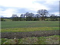
Farmland between Noah's Ark Lane and Knutsford Road
In the centre ground, there is a public right-of-way between the distinct furrows.
Image: © Anthony O'Neil
Taken: 27 Jan 2011
0.20 miles