IMAGES TAKEN NEAR TO
Hall Lane, KNUTSFORD, WA16 7AE
Introduction
This page details the photographs taken nearby to Hall Lane, WA16 7AE by members of the Geograph project.
The Geograph project started in 2005 with the aim of publishing, organising and preserving representative images for every square kilometre of Great Britain, Ireland and the Isle of Man.

There are currently over 7.5m images from over14,400 individuals and you can help contribute to the project by visiting https://www.geograph.org.uk
Image Map (Loading...)


Getting Data...Please wait
Leaflet Map data © OpenStreetMap
Images are licensed for reuse under creativecommons.org/licenses/by-sa/2.0
Notes
- Clicking on the map will re-center to the selected point.
- The higher the marker number, the further away the image location is from the centre of the postcode.
Image Listing (4 Images Found)
Images are licensed for reuse under creativecommons.org/licenses/by-sa/2.0
Image
Details
Distance

2
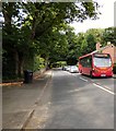
#88 bus on Hall Lane
The D&G bus on Hall Lane (B5085) is on route 88 from Knutsford to Altrincham via Wilmslow.
Image: © Gerald England
Taken: 13 Jul 2017
0.22 miles
3
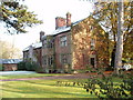
Mobberley Old Hall
An early C17 Grade II* Jacobean manor house, recently sold by the University of Manchester for £2.75m!
Image: © Ian Warburton
Taken: 20 Nov 2005
0.23 miles
4
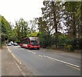
Bus stop on Hall Lane
The D&G bus is on service #88 from Altrincham to Knutsford via Wilmslow.
Image: © Gerald England
Taken: 13 Jul 2017
0.24 miles