IMAGES TAKEN NEAR TO
Hillside Road, KNUTSFORD, WA16 6TH
Introduction
This page details the photographs taken nearby to Hillside Road, WA16 6TH by members of the Geograph project.
The Geograph project started in 2005 with the aim of publishing, organising and preserving representative images for every square kilometre of Great Britain, Ireland and the Isle of Man.

There are currently over 7.5m images from over14,400 individuals and you can help contribute to the project by visiting https://www.geograph.org.uk
Image Map
Images are licensed for reuse under creativecommons.org/licenses/by-sa/2.0
Notes
- Clicking on the map will re-center to the selected point.
- The higher the marker number, the further away the image location is from the centre of the postcode.
Image Listing (115 Images Found)
Images are licensed for reuse under creativecommons.org/licenses/by-sa/2.0
Image
Details
Distance
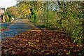
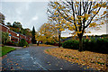
2
A path between Briar Close & Ruskin Way
See also: Image
Image: © Roger A Smith
Taken: 4 Nov 2016
0.03 miles
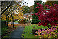
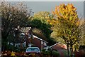
3
A path between Ruskin Way and Briar Close
See also: Image
Image: © Roger A Smith
Taken: 4 Nov 2016
0.04 miles
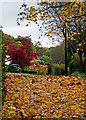
6
Drury lane and not a muffin man in sight
Image: © Roger A Smith
Taken: 7 Nov 2016
0.08 miles
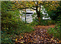
7
The Old Laundry, Drury Lane, Knutsford
Image: © Roger A Smith
Taken: 23 Jan 2012
0.09 miles
8
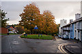
The junction between Drury Lane and Hillside Road
Image: © Roger A Smith
Taken: 4 Nov 2016
0.10 miles
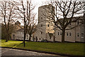
9
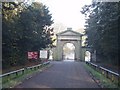
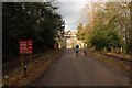
Knutsford Entrance to Tatton Park
This entrance to Tatton Park is close to the junction of Garden road & Mereheath lane
Image: © Ian Warburton
Taken: 19 Nov 2005
0.10 miles