IMAGES TAKEN NEAR TO
Chapel Lane, KNUTSFORD, WA16 6RH
Introduction
This page details the photographs taken nearby to Chapel Lane, WA16 6RH by members of the Geograph project.
The Geograph project started in 2005 with the aim of publishing, organising and preserving representative images for every square kilometre of Great Britain, Ireland and the Isle of Man.

There are currently over 7.5m images from over14,400 individuals and you can help contribute to the project by visiting https://www.geograph.org.uk
Image Map
Images are licensed for reuse under creativecommons.org/licenses/by-sa/2.0
Notes
- Clicking on the map will re-center to the selected point.
- The higher the marker number, the further away the image location is from the centre of the postcode.
Image Listing (20 Images Found)
Images are licensed for reuse under creativecommons.org/licenses/by-sa/2.0
Image
Details
Distance
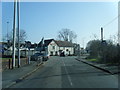
4
Bucklowhill Lane
Not my day for picking routes
Image: © Ian Greig
Taken: 12 Feb 2016
0.17 miles
5
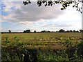
Farmland
This image was taken from SJ726835 looking SW from Chapel Lane near Bucklow Hill.
Image: © Dave Smethurst
Taken: 28 Aug 2005
0.18 miles
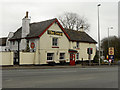
6
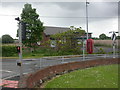
Bucklow Hill, phone exchange
At the junction of Chester Road & Chapel Lane.
Image: © Mike Faherty
Taken: 16 May 2009
0.18 miles
7
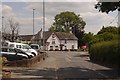
Bucklow Hill
Now quieter after the recent rerouting of the extremely busy A556. The Premier Inn building is shown on old maps as the Swan Inn.
Image: © Richard Webb
Taken: 7 Jul 2018
0.18 miles
8
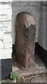
Old Milestone by the B5569, Swan Hotel, Bucklow Hill
Carved stone post by the B5569 (former A556), in parish of MERE (MACCLESFIELD District), Chester Road; Bucklow Hill, Swan Hotel, in outbuilding niche, on East side of road. Altrincham wedge, erected by the Cranage & Warrington turnpike trust in the 18th century.
Inscription illegible.
Milestone Society National ID: CH_ZMER.
Image: © M Faherty
Taken: 16 May 2009
0.19 miles
9
Chapel Lane nears the A556 at Bucklow Hill
Image: © Colin Pyle
Taken: 12 Mar 2014
0.19 miles
10
The Swan, Bucklow Hill
The Swan Hotel; a large pub/restaurant at Bucklow Hill.
Image: © David Dixon
Taken: 13 Apr 2013
0.20 miles