IMAGES TAKEN NEAR TO
Froghall Lane, KNUTSFORD, WA16 6NX
Introduction
This page details the photographs taken nearby to Froghall Lane, WA16 6NX by members of the Geograph project.
The Geograph project started in 2005 with the aim of publishing, organising and preserving representative images for every square kilometre of Great Britain, Ireland and the Isle of Man.

There are currently over 7.5m images from over14,400 individuals and you can help contribute to the project by visiting https://www.geograph.org.uk
Image Map
Images are licensed for reuse under creativecommons.org/licenses/by-sa/2.0
Notes
- Clicking on the map will re-center to the selected point.
- The higher the marker number, the further away the image location is from the centre of the postcode.
Image Listing (11 Images Found)
Images are licensed for reuse under creativecommons.org/licenses/by-sa/2.0
Image
Details
Distance
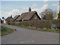
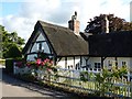
3
Cottage on Agden Lane
Close to the M56.
Image: © Dave Dunford
Taken: 30 Jul 2015
0.18 miles
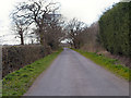
5
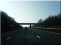
M56 westbound nears Agden Lane overbridge
Image: © Colin Pyle
Taken: 12 Mar 2014
0.20 miles
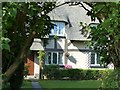
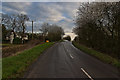
6
Ovenback Cottage
Grade II listed cottage at the junction of Agden and Moss Lanes. http://list.historicengland.org.uk/resultsingle.aspx?uid=1329662
Image: © Dave Dunford
Taken: 30 Jul 2015
0.20 miles

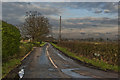
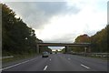
10
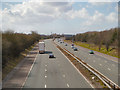
M56 Westbound
Looking westwards along the M56 motorway (towards North Wales) from the bridge at Agden Lane.
Image: © David Dixon
Taken: 16 Apr 2013
0.22 miles