IMAGES TAKEN NEAR TO
West Lane, KNUTSFORD, WA16 6NP
Introduction
This page details the photographs taken nearby to West Lane, WA16 6NP by members of the Geograph project.
The Geograph project started in 2005 with the aim of publishing, organising and preserving representative images for every square kilometre of Great Britain, Ireland and the Isle of Man.

There are currently over 7.5m images from over14,400 individuals and you can help contribute to the project by visiting https://www.geograph.org.uk
Image Map
Images are licensed for reuse under creativecommons.org/licenses/by-sa/2.0
Notes
- Clicking on the map will re-center to the selected point.
- The higher the marker number, the further away the image location is from the centre of the postcode.
Image Listing (8 Images Found)
Images are licensed for reuse under creativecommons.org/licenses/by-sa/2.0
Image
Details
Distance
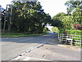
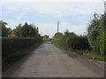
2
The junction of Mowpen Brow with West Lane
Image: © Ian Greig
Taken: 12 Feb 2016
0.08 miles
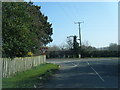
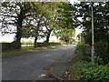
4
Road junction
This junction at SJ702849 shows Peacock lane as it joins West Lane near High Legh
Image: © Dave Smethurst
Taken: 28 Aug 2005
0.15 miles
5
Mowpen Brow
Interestingly named lane near High Legh.
Image: © Peter Whatley
Taken: 5 Oct 2009
0.17 miles
6
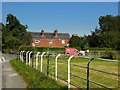
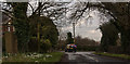
Post Delivery on Peacock Lane, High Legh
Image: © Gary Rogers
Taken: 10 Sep 2014
0.20 miles
7
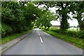
High Legh - West Lane At The Avenue (Northern End)
Image: © Peter Whatley
Taken: 5 Oct 2009
0.21 miles
8
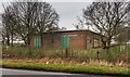
Depot
Depot building near Crossroads Farm seen from West Lane.
Image: © Peter McDermott
Taken: 29 Nov 2014
0.23 miles