IMAGES TAKEN NEAR TO
West Lane, KNUTSFORD, WA16 6NE

Introduction

This page details the photographs taken nearby to West Lane, WA16 6NE by members of the Geograph project.

The Geograph project started in 2005 with the aim of publishing, organising and preserving representative images for every square kilometre of Great Britain, Ireland and the Isle of Man.

There are currently over 7.5m images from over14,400 individuals and you can help contribute to the project by visiting https://www.geograph.org.uk

Image Map


Images are licensed for reuse under creativecommons.org/licenses/by-sa/2.0
Notes
  • Clicking on the map will re-center to the selected point.
  • The higher the marker number, the further away the image location is from the centre of the postcode.

Image Listing (16 Images Found)

Images are licensed for reuse under creativecommons.org/licenses/by-sa/2.0
Image
Details
Distance
1
High Legh - West Lane At The Avenue (Northern End)
Image: © Peter Whatley Taken: 5 Oct 2009
0.04 miles
2
Mowpen Brow nears West Lane
Image: © Colin Pyle Taken: 12 Mar 2014
0.09 miles
3
The junction of Mowpen Brow with West Lane
Image: © Ian Greig Taken: 12 Feb 2016
0.09 miles
4
B5159 West Lane
Image: © Anthony Parkes Taken: 19 Jun 2011
0.11 miles
5
West Lane (B5159) High Legh
The B5159 skirting the western side of High Legh village.
Image: © David Dixon Taken: 16 Apr 2013
0.17 miles
6
St. John's, High Legh
Church of England parish church.
Image: © philandju Taken: 1 May 2015
0.18 miles
7
The Parish Church of St John, High Legh
The original St John's church was built in about 1814 as a chapel for High Legh East Hall. The chapel burnt down in 1891 and the remaining stone walls were used as a base for a new church which was completed in 1893. The church is designated by English Heritage as a Grade II listed building (http://list.english-heritage.org.uk/resultsingle.aspx?uid=1139514 National Heritage List for England).
Image: © David Dixon Taken: 16 Apr 2013
0.18 miles
8
Interior of the Church of St. John at High Legh
Image: © Gary Rogers Taken: 10 Sep 2014
0.18 miles
9
High Legh War Memorial
The War Memorial on The Avenue, outside Image The metal plaque on the boulder reads: In Memory of the men and women of High Legh who lost their lives serving their country. Erected by High Legh parish council to celebrate their centenary anniversary on 4th December 1994.
Image: © David Dixon Taken: 16 Apr 2013
0.18 miles
10
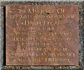
War Memorial Plaque
The plaque on Image] reads: In Memory of the men and women of High Legh who lost their lives serving their country. Erected by High Legh parish council to celebrate their centenary anniversary on 4th December 1994.
Image: © David Dixon Taken: 16 Apr 2013
0.18 miles