IMAGES TAKEN NEAR TO
Smith Lane, KNUTSFORD, WA16 6JY
Introduction
This page details the photographs taken nearby to Smith Lane, WA16 6JY by members of the Geograph project.
The Geograph project started in 2005 with the aim of publishing, organising and preserving representative images for every square kilometre of Great Britain, Ireland and the Isle of Man.

There are currently over 7.5m images from over14,400 individuals and you can help contribute to the project by visiting https://www.geograph.org.uk
Image Map
Images are licensed for reuse under creativecommons.org/licenses/by-sa/2.0
Notes
- Clicking on the map will re-center to the selected point.
- The higher the marker number, the further away the image location is from the centre of the postcode.
Image Listing (24 Images Found)
Images are licensed for reuse under creativecommons.org/licenses/by-sa/2.0
Image
Details
Distance
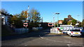
4
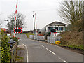
Mobberley Station
The railway station and level crossing at Mobberley.
Image: © Roger May
Taken: 15 Nov 2005
0.10 miles
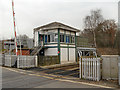
8
Signal Box, Mobberley Station
And level crossing.
Image: © Eirian Evans
Taken: 25 May 2016
0.13 miles
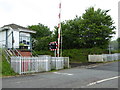
10
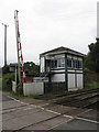
Mobberley Signalbox
A classic Cheshire Lines structure, sympathetically refitted with double-glazing. The box is retained due to the need for level crossing supervision.
Image: © Peter Whatley
Taken: 17 Sep 2009
0.14 miles