IMAGES TAKEN NEAR TO
Broad Oak Lane, KNUTSFORD, WA16 6JP
Introduction
This page details the photographs taken nearby to Broad Oak Lane, WA16 6JP by members of the Geograph project.
The Geograph project started in 2005 with the aim of publishing, organising and preserving representative images for every square kilometre of Great Britain, Ireland and the Isle of Man.

There are currently over 7.5m images from over14,400 individuals and you can help contribute to the project by visiting https://www.geograph.org.uk
Image Map
Images are licensed for reuse under creativecommons.org/licenses/by-sa/2.0
Notes
- Clicking on the map will re-center to the selected point.
- The higher the marker number, the further away the image location is from the centre of the postcode.
Image Listing (4 Images Found)
Images are licensed for reuse under creativecommons.org/licenses/by-sa/2.0
Image
Details
Distance
1
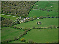
Brookdale Lane from the air
Part of Raleigh Wood can be seen in the top left corner. Viewed from a flight from Prague seconds before touchdown at Manchester.
Image: © Thomas Nugent
Taken: 18 Apr 2014
0.13 miles
2
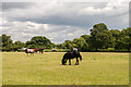
Mobberley
Horses in field near Mobberley.
Image: © Peter McDermott
Taken: 11 Aug 2014
0.14 miles
4
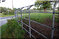
Cheshire Railings
All over Cheshire road/lane junctions have hedges replaced by metal railings to aid visibility. These railing have been renewed by Mobberley Village Society* and awaiting a coat of paint, normally black and white.
* http://www.mvs1975.org/html/cheshire_railings_.html
Image: © Roger Gittins
Taken: 13 Sep 2006
0.18 miles