IMAGES TAKEN NEAR TO
Marcliff Grove, KNUTSFORD, WA16 6JE
Introduction
This page details the photographs taken nearby to Marcliff Grove, WA16 6JE by members of the Geograph project.
The Geograph project started in 2005 with the aim of publishing, organising and preserving representative images for every square kilometre of Great Britain, Ireland and the Isle of Man.

There are currently over 7.5m images from over14,400 individuals and you can help contribute to the project by visiting https://www.geograph.org.uk
Image Map
Images are licensed for reuse under creativecommons.org/licenses/by-sa/2.0
Notes
- Clicking on the map will re-center to the selected point.
- The higher the marker number, the further away the image location is from the centre of the postcode.
Image Listing (258 Images Found)
Images are licensed for reuse under creativecommons.org/licenses/by-sa/2.0
Image
Details
Distance
2
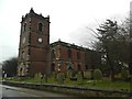
St. John The Baptist Church, Knutsford
Image: © Roger A Smith
Taken: 26 Aug 2013
0.04 miles
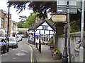
3
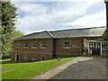
St John's Church Centre, Knutsford
A building on two levels attached to the east side of the parish church.
Image: © Stephen Craven
Taken: 11 Apr 2022
0.04 miles
4
The footpath disappears at this point on the west side of King Street
Image: © Roger A Smith
Taken: 26 Jan 2012
0.04 miles
5
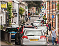
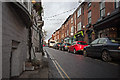
King Street
View looking along King Street in Knutsford.
Image: © Peter McDermott
Taken: 11 Aug 2014
0.04 miles
6
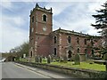
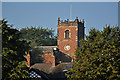
St John the Baptist, Knutsford - west side
The church dates from 1741-4, architect J Garlive, extended in 1879. Unusually for a parish church, it is aligned nearly north-south rather than west-east although there would have been room on the site for a conventional orientation. Grade II* listed (list entry 1388324).
Image: © Stephen Craven
Taken: 11 Apr 2022
0.05 miles
8
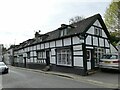
38-42 King Street, Knutsford
A row of early 17th century houses with later alterations, listed grade II (list entry 1388353).
Image: © Stephen Craven
Taken: 11 Apr 2022
0.05 miles
9
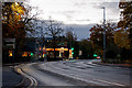
The A50, Toft Road, near the junction with the A537
Image: © Roger A Smith
Taken: 5 Nov 2016
0.05 miles
10
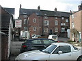
Norbury's Yard, Knutsford
A view of the rear of 15-23 King Street.
Image: © John Brightley
Taken: Unknown
0.05 miles