IMAGES TAKEN NEAR TO
Tatton Street, KNUTSFORD, WA16 6AB
Introduction
This page details the photographs taken nearby to Tatton Street, WA16 6AB by members of the Geograph project.
The Geograph project started in 2005 with the aim of publishing, organising and preserving representative images for every square kilometre of Great Britain, Ireland and the Isle of Man.

There are currently over 7.5m images from over14,400 individuals and you can help contribute to the project by visiting https://www.geograph.org.uk
Image Map
Images are licensed for reuse under creativecommons.org/licenses/by-sa/2.0
Notes
- Clicking on the map will re-center to the selected point.
- The higher the marker number, the further away the image location is from the centre of the postcode.
Image Listing (260 Images Found)
Images are licensed for reuse under creativecommons.org/licenses/by-sa/2.0
Image
Details
Distance
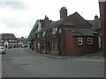
1
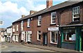
Minshull Street, Knutsford
Looking down the south side of the street from the junction with Tatton Street.
Image: © Derek Harper
Taken: 29 Jun 2006
0.01 miles
2
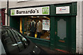
Barnardo's Charity Shop, Tatton Street, Knutsford
Image: © Roger A Smith
Taken: 26 Jan 2012
0.01 miles
4
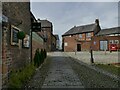
Heritage Way, Knutsford
A courtyard outside the Heritage Centre (left).
Image: © Stephen Craven
Taken: 11 Apr 2022
0.01 miles
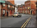
5
The Lord Eldon, 27 Tatton Street Knutsford
Image: © Roger A Smith
Taken: 26 Aug 2013
0.01 miles
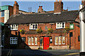
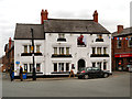
6
The Lord Eldon, Tatton Street, Knutsford
A pub with 18th century origins, originally known as the Duke of Wellington, listed grade II (list entry 1378493).
Image: © Stephen Craven
Taken: 11 Apr 2022
0.01 miles
7
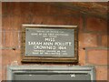
Plaque on the Lord Eldon
The plaque records that Sarah Ann Pollitt became the town's first May Queen in 1864. The significance of the location is that she was the landlord's daughter and her ghost is said to haunt the pub (source: https://www.mysteriousbritain.co.uk/hauntings/the-lord-eldon-knutsford/ ). See Image for context.
Image: © Stephen Craven
Taken: 11 Apr 2022
0.01 miles
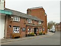
8
Knutsford, Lord Eldon
Cosy pub in Tatton Street; 2009 Good Beer Guide-listed. Internally, four drinking areas around a semi-circular bar. Cask ales on offer at my visit: Blakemere Heyday, Bass, Tetley Cask. English Heritage-listed; http://www.imagesofengland.org.uk/Details/Default.aspx?id=476443&mode=adv. For some customer reviews, see http://www.beerintheevening.com/pubs/s/28/28069/Lord_Eldon/Knutsford
Image: © Mike Faherty
Taken: 16 May 2009
0.02 miles
9
The Red Cow, Knutsford
The Red Cow was originally built in 1758.
Image: © David Dixon
Taken: 4 May 2012
0.02 miles
10
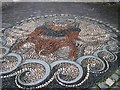
King Canute mosaic, Knutsford
Knutsford was recorded in the Domesday Book of 1086 as Cunetesford ("Canute's ford"). King Canute (Knútr in Old Norse) was the king of England (1016–1035). Local tradition says that King Canute forded the River Lily, which was said to be dangerous then, though other reports say it was the Birkin Brook at or near Booth Mill. The English Place-Name Society gives the name as being derived from the Old English for Knutr's ford or possibly hillock ford.
The mosaic is on Canute Place, next to the Old Sessions House pub.
Image: © Tricia Neal
Taken: 31 May 2012
0.02 miles