IMAGES TAKEN NEAR TO
Clover Drive, KNUTSFORD, WA16 0WF
Introduction
This page details the photographs taken nearby to Clover Drive, WA16 0WF by members of the Geograph project.
The Geograph project started in 2005 with the aim of publishing, organising and preserving representative images for every square kilometre of Great Britain, Ireland and the Isle of Man.

There are currently over 7.5m images from over14,400 individuals and you can help contribute to the project by visiting https://www.geograph.org.uk
Image Map
Images are licensed for reuse under creativecommons.org/licenses/by-sa/2.0
Notes
- Clicking on the map will re-center to the selected point.
- The higher the marker number, the further away the image location is from the centre of the postcode.
Image Listing (21 Images Found)
Images are licensed for reuse under creativecommons.org/licenses/by-sa/2.0
Image
Details
Distance
1
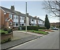
Around Pickmere (8)
Houses on Mere Lane
Image: © Anthony O'Neil
Taken: 17 Feb 2022
0.07 miles
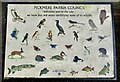
2
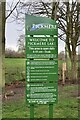
Around Pickmere (9)
Tourist information board
Image: © Anthony O'Neil
Taken: 17 Feb 2022
0.08 miles
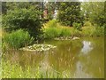
5

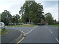
Around Pickmere (10)
Towards The Mere
Image: © Anthony O'Neil
Taken: 17 Feb 2022
0.11 miles
7
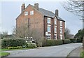
Around Pickmere (4)
Pickmere Country House
Image: © Anthony O'Neil
Taken: 17 Feb 2022
0.15 miles
9
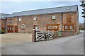
Around Pickmere (14)
Mere View Farm: owners of nearby Pick Mere lake
Image: © Anthony O'Neil
Taken: 17 Feb 2022
0.18 miles
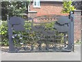
10
Around Pickmere (13)
Information board at Pick Mere
Image: © Anthony O'Neil
Taken: 17 Feb 2022
0.19 miles