IMAGES TAKEN NEAR TO
Warrington Road, KNUTSFORD, WA16 0WA
Introduction
This page details the photographs taken nearby to Warrington Road, WA16 0WA by members of the Geograph project.
The Geograph project started in 2005 with the aim of publishing, organising and preserving representative images for every square kilometre of Great Britain, Ireland and the Isle of Man.

There are currently over 7.5m images from over14,400 individuals and you can help contribute to the project by visiting https://www.geograph.org.uk
Image Map
Images are licensed for reuse under creativecommons.org/licenses/by-sa/2.0
Notes
- Clicking on the map will re-center to the selected point.
- The higher the marker number, the further away the image location is from the centre of the postcode.
Image Listing (5 Images Found)
Images are licensed for reuse under creativecommons.org/licenses/by-sa/2.0
Image
Details
Distance
2
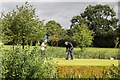
High Legh Golf Course
The 8th hole at High Legh Golf Course.
Image: © Peter McDermott
Taken: 21 Aug 2016
0.16 miles
3
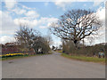
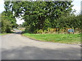
Broadoak Lane, High Legh
The junction of Wrenshot Lane and Broadoak Lane near High Legh village.
Image: © David Dixon
Taken: 16 Apr 2013
0.19 miles