IMAGES TAKEN NEAR TO
Plumley Moor Road, KNUTSFORD, WA16 0TU
Introduction
This page details the photographs taken nearby to Plumley Moor Road, WA16 0TU by members of the Geograph project.
The Geograph project started in 2005 with the aim of publishing, organising and preserving representative images for every square kilometre of Great Britain, Ireland and the Isle of Man.

There are currently over 7.5m images from over14,400 individuals and you can help contribute to the project by visiting https://www.geograph.org.uk
Image Map (Loading...)


Getting Data...Please wait
Leaflet Map data © OpenStreetMap
Images are licensed for reuse under creativecommons.org/licenses/by-sa/2.0
Notes
- Clicking on the map will re-center to the selected point.
- The higher the marker number, the further away the image location is from the centre of the postcode.
Image Listing (7 Images Found)
Images are licensed for reuse under creativecommons.org/licenses/by-sa/2.0
Image
Details
Distance
1
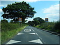
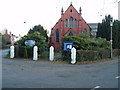
Plumley Moor Road at Plumley village boundary
Image: © Colin Pyle
Taken: 10 Aug 2012
0.02 miles
2
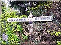
Old Direction Sign - Signpost by Troutmoor Lane, Plumley parish
Pawn finial - 2 arms; Cheshire CCC octagonal in parish of Plumley (Macclesfield District), Troutmoor Lane junction with Plumley Moor Lane, near Plumley Post Office.
To be surveyed
Milestone Society National ID: CH_SJ7175
Image: © Milestone Society
Taken: Unknown
0.06 miles
4
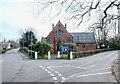
Plumley Methodist Church
Situated in the centre of Plumley at the junction of Trouthall Lane and Plumley moor road.
Image: © Ian Warburton
Taken: 25 Nov 2005
0.14 miles