IMAGES TAKEN NEAR TO
Manchester Road, KNUTSFORD, WA16 0SZ
Introduction
This page details the photographs taken nearby to Manchester Road, WA16 0SZ by members of the Geograph project.
The Geograph project started in 2005 with the aim of publishing, organising and preserving representative images for every square kilometre of Great Britain, Ireland and the Isle of Man.

There are currently over 7.5m images from over14,400 individuals and you can help contribute to the project by visiting https://www.geograph.org.uk
Image Map
Images are licensed for reuse under creativecommons.org/licenses/by-sa/2.0
Notes
- Clicking on the map will re-center to the selected point.
- The higher the marker number, the further away the image location is from the centre of the postcode.
Image Listing (8 Images Found)
Images are licensed for reuse under creativecommons.org/licenses/by-sa/2.0
Image
Details
Distance
5
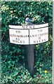
Old Milepost by the A5034 in Mere
Cast iron post by the A5034, in parish of Mere (Macclesfield District), South of Mereheath Lane junction, in hawthorn hedge, on West side of road. Old domed open book, erected by the Cranage & Warrington turnpike trust in the 19th century.
Inscription reads:-
: TO / ALTRINCHAM / 5¼ / MILES : : MERE : : TO / KNUTSFORD / 2 / MILES :
Milestone Society National ID: CH_KNAL02
Image: © J Higgins
Taken: 1 Jun 2003
0.21 miles
7
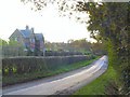
Meremoss
Cottages below Mere Platt farm, opposite Meremoss Wood.
Image: © Roger May
Taken: 15 Nov 2005
0.24 miles