IMAGES TAKEN NEAR TO
Warrington Road, KNUTSFORD, WA16 0SH
Introduction
This page details the photographs taken nearby to Warrington Road, WA16 0SH by members of the Geograph project.
The Geograph project started in 2005 with the aim of publishing, organising and preserving representative images for every square kilometre of Great Britain, Ireland and the Isle of Man.

There are currently over 7.5m images from over14,400 individuals and you can help contribute to the project by visiting https://www.geograph.org.uk
Image Map
Images are licensed for reuse under creativecommons.org/licenses/by-sa/2.0
Notes
- Clicking on the map will re-center to the selected point.
- The higher the marker number, the further away the image location is from the centre of the postcode.
Image Listing (12 Images Found)
Images are licensed for reuse under creativecommons.org/licenses/by-sa/2.0
Image
Details
Distance
4
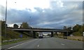
A50, Primrose Hill
The bridge taking the A50 over the M56 motorway.
Image: © David Dixon
Taken: 16 Jun 2013
0.10 miles
5
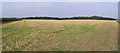
Cropped Field
This image centred looking NE from SJ-67846-84643 across a wheat field that had obviously been recently harvested.
Image: © Dave Smethurst
Taken: 3 Sep 2005
0.10 miles
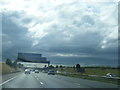
6
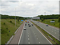
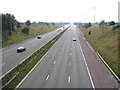
M56, Primrose Hill
Looking eastwards, along the M56, from the bridge carrying the A50.
Image: © David Dixon
Taken: 16 Jun 2013
0.11 miles
7
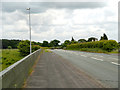
A50 bridge over M56
Why are there lamps on the westbound carriageway, and not on the eastbound?
Image: © David Smith
Taken: 24 Oct 2019
0.11 miles

9
M56 Westbound
This image was taken from the A50 bridge over the M56 looking WSW towards junction 9 (SJ-67696-84570)
Image: © Dave Smethurst
Taken: 3 Sep 2005
0.18 miles