IMAGES TAKEN NEAR TO
Withers Lane, KNUTSFORD, WA16 0SG
Introduction
This page details the photographs taken nearby to Withers Lane, WA16 0SG by members of the Geograph project.
The Geograph project started in 2005 with the aim of publishing, organising and preserving representative images for every square kilometre of Great Britain, Ireland and the Isle of Man.

There are currently over 7.5m images from over14,400 individuals and you can help contribute to the project by visiting https://www.geograph.org.uk
Image Map
Images are licensed for reuse under creativecommons.org/licenses/by-sa/2.0
Notes
- Clicking on the map will re-center to the selected point.
- The higher the marker number, the further away the image location is from the centre of the postcode.
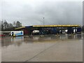
Image Listing (8 Images Found)
Images are licensed for reuse under creativecommons.org/licenses/by-sa/2.0
Image
Details
Distance
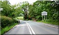
1
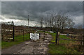
A private bridge over the motorway slip road
Image: © Ian Greig
Taken: 5 Feb 2016
0.08 miles
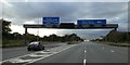
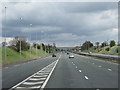
4
M6/M56 Interchange
The sliproad from junction 20 of the southbound M6, passing under the eastbound M56 on its way to joining the westbound M56 at Junction 9.
Image: © David Dixon
Taken: 9 Nov 2010
0.20 miles
5
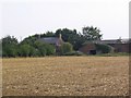
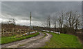
Farm (disused)
This image was taken from SJ-67364-84760 looking south across fields to these disused farm buildings.
Image: © Dave Smethurst
Taken: 3 Sep 2005
0.23 miles
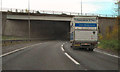
8
The M6 sliproad joins the M56 towards Manchester
Image: © Ian S
Taken: 22 Apr 2012
0.24 miles