IMAGES TAKEN NEAR TO
Swineyard Lane, KNUTSFORD, WA16 0SD
Introduction
This page details the photographs taken nearby to Swineyard Lane, WA16 0SD by members of the Geograph project.
The Geograph project started in 2005 with the aim of publishing, organising and preserving representative images for every square kilometre of Great Britain, Ireland and the Isle of Man.

There are currently over 7.5m images from over14,400 individuals and you can help contribute to the project by visiting https://www.geograph.org.uk
Image Map
Images are licensed for reuse under creativecommons.org/licenses/by-sa/2.0
Notes
- Clicking on the map will re-center to the selected point.
- The higher the marker number, the further away the image location is from the centre of the postcode.
Image Listing (8 Images Found)
Images are licensed for reuse under creativecommons.org/licenses/by-sa/2.0
Image
Details
Distance
1
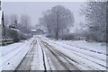
Shades of grey
Not much colour shows through the grey light beneath snow-laden clouds
Image: © David Long
Taken: 4 Mar 2006
0.11 miles
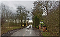
3
Tell-tale tracks
A last-minute change of direction by a confused driver is recorded in the snow for posterity at the M6/M56/A50 junction.
Image: © David Long
Taken: 4 Mar 2006
0.20 miles
4
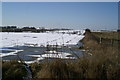
Whiteout at Blackcap
The runway of the wartime Fleet Air Arm airfield, HMS Blackcap, from the east.
Image: © David Long
Taken: 4 Mar 2006
0.20 miles
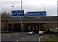
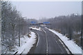
7
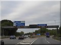
Gantry over M56 junction with M6
The two lanes are for eastbound traffic leaving the M56 to join the M6; here the roads separate into north and south lanes
Image: © David Smith
Taken: 7 Oct 2016
0.25 miles
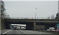
8
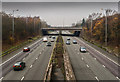
M6 Motorway
The M6 motorway at its junction with the M56.
Image: © Peter McDermott
Taken: 29 Nov 2014
0.25 miles