IMAGES TAKEN NEAR TO
Fanners Lane, KNUTSFORD, WA16 0RZ
Introduction
This page details the photographs taken nearby to Fanners Lane, WA16 0RZ by members of the Geograph project.
The Geograph project started in 2005 with the aim of publishing, organising and preserving representative images for every square kilometre of Great Britain, Ireland and the Isle of Man.

There are currently over 7.5m images from over14,400 individuals and you can help contribute to the project by visiting https://www.geograph.org.uk
Image Map
Images are licensed for reuse under creativecommons.org/licenses/by-sa/2.0
Notes
- Clicking on the map will re-center to the selected point.
- The higher the marker number, the further away the image location is from the centre of the postcode.
Image Listing (12 Images Found)
Images are licensed for reuse under creativecommons.org/licenses/by-sa/2.0
Image
Details
Distance
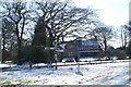
1
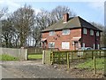
Houses at Rowlinson's Green
Semi-detached houses on the edge of woodland on Fanner's Lane, Rowlinson's Green (High Legh).
Image: © Mike Harris
Taken: 24 Mar 2007
0.01 miles
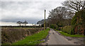
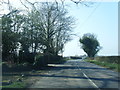
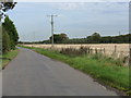
3
Footpath to Rowlinson's Green off Swineyard Lane
Image: © Ian Greig
Taken: 5 Feb 2016
0.15 miles
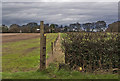
5
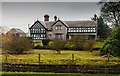
Where there's muck...
This ancient and handsome pile carries the name Swineyard Hall.
Image: © David Long
Taken: 4 Mar 2006
0.19 miles
8
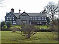
Swineyard Hall
Swineyard Hall, Swineyard Lane, High Legh - front (north) elevation.
Image: © Mike Harris
Taken: 24 Mar 2007
0.23 miles
9
Swinyard Hall
The house at Swineyard Hall farm.
Image: © Peter McDermott
Taken: 29 Nov 2014
0.23 miles
10
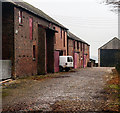
Swinyard Hall
Barns at Swinyard Hall farm.
Image: © Peter McDermott
Taken: 29 Nov 2014
0.23 miles