IMAGES TAKEN NEAR TO
Moss Lane, KNUTSFORD, WA16 0RH
Introduction
This page details the photographs taken nearby to Moss Lane, WA16 0RH by members of the Geograph project.
The Geograph project started in 2005 with the aim of publishing, organising and preserving representative images for every square kilometre of Great Britain, Ireland and the Isle of Man.

There are currently over 7.5m images from over14,400 individuals and you can help contribute to the project by visiting https://www.geograph.org.uk
Image Map (Loading...)


Getting Data...Please wait
Leaflet Map data © OpenStreetMap
Images are licensed for reuse under creativecommons.org/licenses/by-sa/2.0
Notes
- Clicking on the map will re-center to the selected point.
- The higher the marker number, the further away the image location is from the centre of the postcode.
Image Listing (6 Images Found)
Images are licensed for reuse under creativecommons.org/licenses/by-sa/2.0
Image
Details
Distance
5
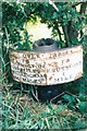
Old Milepost by the A50, north of Knutsford
Cast iron post by the A50, in parish of Knutsford (Macclesfield District), opposite Bluebell Farm, on the verge by hedge, on West side of road. Old acorn open book, erected by the Cranage & Warrington turnpike trust in the 19th century.
Inscription reads:-
: TO / WARRINGTON / 10½ MILES / ALTRINGHAM / 6¼ MILES : : OVER TABLEY : : TO / KNUTSFORD / 1 / MILE :
Milestone Society National ID: CH_KFWA01
Image: © J Higgins
Taken: 1 Jun 2003
0.23 miles
6
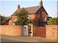
Bluebell Farm
Next to the busy A50 near Knutsford
Image: © Mary Gracie
Taken: 17 Feb 2008
0.24 miles