IMAGES TAKEN NEAR TO
Hobbs Hill Lane, KNUTSFORD, WA16 0QZ
Introduction
This page details the photographs taken nearby to Hobbs Hill Lane, WA16 0QZ by members of the Geograph project.
The Geograph project started in 2005 with the aim of publishing, organising and preserving representative images for every square kilometre of Great Britain, Ireland and the Isle of Man.

There are currently over 7.5m images from over14,400 individuals and you can help contribute to the project by visiting https://www.geograph.org.uk
Image Map
Images are licensed for reuse under creativecommons.org/licenses/by-sa/2.0
Notes
- Clicking on the map will re-center to the selected point.
- The higher the marker number, the further away the image location is from the centre of the postcode.
Image Listing (6 Images Found)
Images are licensed for reuse under creativecommons.org/licenses/by-sa/2.0
Image
Details
Distance
1

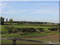
Arleyview Farm, High Legh
"The Willows", barn conversion near Arley View Farm on Hobbs Hill Lane, High Legh. The farm itself to the right of the barns.
Image: © Mike Harris
Taken: 24 Mar 2007
0.02 miles
2
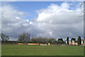
Traffic jam buster
Helicopter in the grounds of Arleyview Farm, near the busy M6
Image: © David Long
Taken: 3 Apr 2006
0.05 miles
5
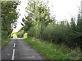
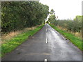
Why The White Line?
Absurd markings on Hobbs Hill Lane, a single-track road.
Image: © Peter Whatley
Taken: 5 Oct 2009
0.20 miles