IMAGES TAKEN NEAR TO
Rowley Bank Lane, KNUTSFORD, WA16 0QJ
Introduction
This page details the photographs taken nearby to Rowley Bank Lane, WA16 0QJ by members of the Geograph project.
The Geograph project started in 2005 with the aim of publishing, organising and preserving representative images for every square kilometre of Great Britain, Ireland and the Isle of Man.

There are currently over 7.5m images from over14,400 individuals and you can help contribute to the project by visiting https://www.geograph.org.uk
Image Map
Images are licensed for reuse under creativecommons.org/licenses/by-sa/2.0
Notes
- Clicking on the map will re-center to the selected point.
- The higher the marker number, the further away the image location is from the centre of the postcode.
Image Listing (6 Images Found)
Images are licensed for reuse under creativecommons.org/licenses/by-sa/2.0
Image
Details
Distance
2
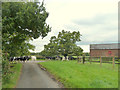
Milking time at Rowleybank Farm, High Legh
Image: © Gary Rogers
Taken: 8 Oct 2015
0.18 miles
4
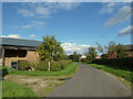
Rowley Bank Lane, High Legh
Lovely pear tree on left
Image: © Gary Rogers
Taken: 8 Oct 2015
0.19 miles
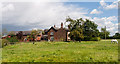
5
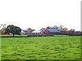
Rowley Bank Farm
Viewed across the fields from Hoo Green Lane, in a setting November afternoon sun.
Image: © Roger May
Taken: 15 Nov 2005
0.20 miles
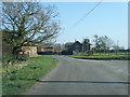
6
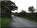
Whitley Lane At Rowley Bank Lane Junction
Image: © Peter Whatley
Taken: 5 Oct 2009
0.21 miles