IMAGES TAKEN NEAR TO
Bexton Road, KNUTSFORD, WA16 0PF
Introduction
This page details the photographs taken nearby to Bexton Road, WA16 0PF by members of the Geograph project.
The Geograph project started in 2005 with the aim of publishing, organising and preserving representative images for every square kilometre of Great Britain, Ireland and the Isle of Man.

There are currently over 7.5m images from over14,400 individuals and you can help contribute to the project by visiting https://www.geograph.org.uk
Image Map
Images are licensed for reuse under creativecommons.org/licenses/by-sa/2.0
Notes
- Clicking on the map will re-center to the selected point.
- The higher the marker number, the further away the image location is from the centre of the postcode.
Image Listing (186 Images Found)
Images are licensed for reuse under creativecommons.org/licenses/by-sa/2.0
Image
Details
Distance
1
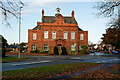
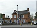
Formerly the offices of Bucklow Rural District Council
Image: © Roger A Smith
Taken: 5 Nov 2016
0.00 miles
2
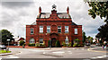
Bucklow
Impressive building at the junction of Bexton Road and Stanley Road in Knutsford.
Image: © Peter McDermott
Taken: 11 Aug 2014
0.01 miles
3
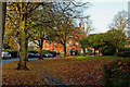
Stanley Road behind Booths supermarket
Beyond the trees is the building once used by the Bucklow Rural District Council
Image: © Roger A Smith
Taken: 5 Nov 2016
0.05 miles
4
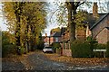
One end of St John's Avenue, Knutsford
Image: © Roger A Smith
Taken: 5 Nov 2016
0.08 miles
5
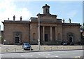
Sessions House, Knutsford
In neo-Greek style, by George Moneypenny (though Pevsner attributed it to Thomas Harrison) in 1815-18. Grade II* listed.
A prison originally stood behind, but has since been demolished.
Image: © Stephen Richards
Taken: Unknown
0.09 miles
6
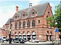
Former Town Hall, Knutsford
By Alfred Waterhouse, 1870-72, in his characteristic Gothic style. Of red and black brick with the five large pointed windows of the ex-Council Room. Grade II listed.
Image: © Stephen Richards
Taken: Unknown
0.11 miles
7

Elizabeth Gaskells House
This famous house, on Gaskell avenue looks out across the "Little Heath" and also the larger Heath
Image: © Ian Warburton
Taken: 19 Nov 2005
0.12 miles
8
Around Knutsford (20)
Police Station
Image: © Anthony O'Neil
Taken: 22 Feb 2022
0.12 miles
9
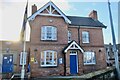
Police Station, Toft Road, Knutsford
Still in use by the Cheshire Constabulary, with the county flag flying outside. See Image for a closer view of the main building.
Image: © Stephen Craven
Taken: 11 Apr 2022
0.12 miles
10
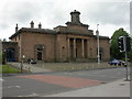
Knutsford, Sessions House
On Toft Road; Sessions House and former gaol, built 1815-8. English Heritage-listed, http://www.imagesofengland.org.uk/Details/Default.aspx?id=476451&mode=adv
Image: © Mike Faherty
Taken: 16 May 2009
0.13 miles