IMAGES TAKEN NEAR TO
Tabley Road, KNUTSFORD, WA16 0NE
Introduction
This page details the photographs taken nearby to Tabley Road, WA16 0NE by members of the Geograph project.
The Geograph project started in 2005 with the aim of publishing, organising and preserving representative images for every square kilometre of Great Britain, Ireland and the Isle of Man.

There are currently over 7.5m images from over14,400 individuals and you can help contribute to the project by visiting https://www.geograph.org.uk
Image Map
Images are licensed for reuse under creativecommons.org/licenses/by-sa/2.0
Notes
- Clicking on the map will re-center to the selected point.
- The higher the marker number, the further away the image location is from the centre of the postcode.
Image Listing (6 Images Found)
Images are licensed for reuse under creativecommons.org/licenses/by-sa/2.0
Image
Details
Distance
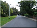
2
Knutsford - Manchester Road
The A50 taken at the junction with Garden Road.
Image: © Peter Whatley
Taken: 27 Feb 2009
0.18 miles
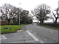
5
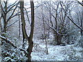
Woodland along the Ladies Mile, Knutsford
Image: © Schlosser67
Taken: 17 Dec 2011
0.23 miles
6
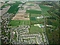
Knutsford from the air
Playing fields in the northwest corner of Knutsford. Viewed from a flight from Prague on approach to Manchester.
Image: © Thomas Nugent
Taken: 18 Apr 2014
0.24 miles