IMAGES TAKEN NEAR TO
Pickmere Lane, KNUTSFORD, WA16 0JB
Introduction
This page details the photographs taken nearby to Pickmere Lane, WA16 0JB by members of the Geograph project.
The Geograph project started in 2005 with the aim of publishing, organising and preserving representative images for every square kilometre of Great Britain, Ireland and the Isle of Man.

There are currently over 7.5m images from over14,400 individuals and you can help contribute to the project by visiting https://www.geograph.org.uk
Image Map
Images are licensed for reuse under creativecommons.org/licenses/by-sa/2.0
Notes
- Clicking on the map will re-center to the selected point.
- The higher the marker number, the further away the image location is from the centre of the postcode.
Image Listing (3 Images Found)
Images are licensed for reuse under creativecommons.org/licenses/by-sa/2.0
Image
Details
Distance
2
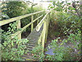
Footbridge over Waterless Brook
Not an appropriate name the day I saw the brook fast flowing under the bridge
Image: © Maggie Cox
Taken: 21 Oct 2013
0.22 miles
3
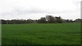
A large field
This field is much larger than most around here where there are numerous horticultural plots and horse paddocks. The clump of trees surround a pond, one of many hereabouts.
Image: © Richard Webb
Taken: 31 Mar 2012
0.24 miles