IMAGES TAKEN NEAR TO
Chester Road, KNUTSFORD, WA16 0HQ
Introduction
This page details the photographs taken nearby to Chester Road, WA16 0HQ by members of the Geograph project.
The Geograph project started in 2005 with the aim of publishing, organising and preserving representative images for every square kilometre of Great Britain, Ireland and the Isle of Man.

There are currently over 7.5m images from over14,400 individuals and you can help contribute to the project by visiting https://www.geograph.org.uk
Image Map
Images are licensed for reuse under creativecommons.org/licenses/by-sa/2.0
Notes
- Clicking on the map will re-center to the selected point.
- The higher the marker number, the further away the image location is from the centre of the postcode.
Image Listing (14 Images Found)
Images are licensed for reuse under creativecommons.org/licenses/by-sa/2.0
Image
Details
Distance
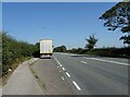
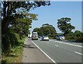
3
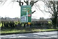
A556 at Smoker Hill Farm entrance
Footpath sign to the left
Image: © John Firth
Taken: 12 Apr 2015
0.15 miles
6
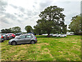
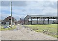
Car Park at the Royal Cheshire County Show 2019
Part of the car park at the Royal Cheshire County Show 2019.
Image: © Jeff Buck
Taken: 18 Jun 2019
0.17 miles
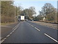
10
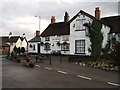
The Smoker Inn Plumley
Situated on the A556 at the junction with Plumley Moor Road.
The Smoker was a 16th-century coaching inn, named after the Prince Regent's racehorse.
Image: © Ian Warburton
Taken: 4 Dec 2005
0.23 miles