IMAGES TAKEN NEAR TO
Tabley Lane, KNUTSFORD, WA16 0EY
Introduction
This page details the photographs taken nearby to Tabley Lane, WA16 0EY by members of the Geograph project.
The Geograph project started in 2005 with the aim of publishing, organising and preserving representative images for every square kilometre of Great Britain, Ireland and the Isle of Man.

There are currently over 7.5m images from over14,400 individuals and you can help contribute to the project by visiting https://www.geograph.org.uk
Image Map
Images are licensed for reuse under creativecommons.org/licenses/by-sa/2.0
Notes
- Clicking on the map will re-center to the selected point.
- The higher the marker number, the further away the image location is from the centre of the postcode.
Image Listing (11 Images Found)
Images are licensed for reuse under creativecommons.org/licenses/by-sa/2.0
Image
Details
Distance
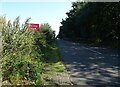
2
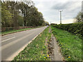
A muddy footpath alongside the A5033
Image: © Christine Johnstone
Taken: 6 Dec 2009
0.01 miles
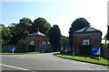
3
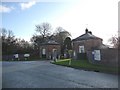
The western lodge, Tabley House drive
Image: © Christine Johnstone
Taken: 6 Dec 2009
0.02 miles
4
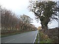
Winter trees, looking west along the A5033
Image: © Christine Johnstone
Taken: 6 Dec 2009
0.03 miles
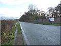
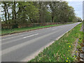
5
Knutsford, Northwich Road
The A5033 near Knutsford Services.
Image: © David Dixon
Taken: 15 Apr 2022
0.03 miles
6
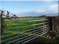
Gateway into field, on the A5033
Image: © Christine Johnstone
Taken: 6 Dec 2009
0.03 miles
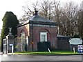
9
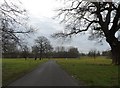
The Grounds of Tabley House
Now an old people's home and tea room
Image: © Anthony Parkes
Taken: 5 Mar 2014
0.06 miles