IMAGES TAKEN NEAR TO
Tabley Hill Lane, KNUTSFORD, WA16 0ER
Introduction
This page details the photographs taken nearby to Tabley Hill Lane, WA16 0ER by members of the Geograph project.
The Geograph project started in 2005 with the aim of publishing, organising and preserving representative images for every square kilometre of Great Britain, Ireland and the Isle of Man.

There are currently over 7.5m images from over14,400 individuals and you can help contribute to the project by visiting https://www.geograph.org.uk
Image Map
Images are licensed for reuse under creativecommons.org/licenses/by-sa/2.0
Notes
- Clicking on the map will re-center to the selected point.
- The higher the marker number, the further away the image location is from the centre of the postcode.
Image Listing (14 Images Found)
Images are licensed for reuse under creativecommons.org/licenses/by-sa/2.0
Image
Details
Distance
1
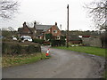
Houses at the Corner
Perched by the M6, one of the old houses is, appropriately, the lair of a car recovery operator.
Image: © Peter Whatley
Taken: 27 Feb 2009
0.01 miles
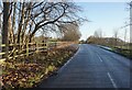
2
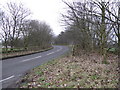
Up and Over
The lane to Tabley Hill rises to bridge the M6 motorway.
Image: © Peter Whatley
Taken: 27 Feb 2009
0.07 miles
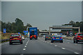
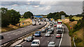
4
Traffic jam on the M6 near Knutsford Services
Image: © Roger Cornfoot
Taken: 13 Oct 2013
0.11 miles
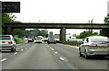
6
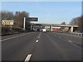
M6 Motorway - Tabley Hill Lane overbridge
Image: © Peter Whatley
Taken: 21 Jan 2011
0.12 miles
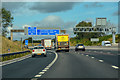
7
Tabley Superior : M6 Motorway
The M6 between Junction 19 and Junction 18.
Image: © Lewis Clarke
Taken: 27 Sep 2019
0.12 miles
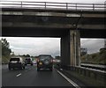
9
Tabley Superior : M6 Motorway
The M6 Motorway between Junction 18 and Junction 19.
Image: © Lewis Clarke
Taken: 23 Sep 2019
0.16 miles
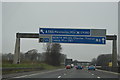
10
M6 Motorway
The M6 Motorway seen from Tabley Hill Lane.
Image: © Peter McDermott
Taken: 11 Aug 2014
0.16 miles