IMAGES TAKEN NEAR TO
Tabley Road, KNUTSFORD, WA16 0EN
Introduction
This page details the photographs taken nearby to Tabley Road, WA16 0EN by members of the Geograph project.
The Geograph project started in 2005 with the aim of publishing, organising and preserving representative images for every square kilometre of Great Britain, Ireland and the Isle of Man.

There are currently over 7.5m images from over14,400 individuals and you can help contribute to the project by visiting https://www.geograph.org.uk
Image Map
Images are licensed for reuse under creativecommons.org/licenses/by-sa/2.0
Notes
- Clicking on the map will re-center to the selected point.
- The higher the marker number, the further away the image location is from the centre of the postcode.
Image Listing (7 Images Found)
Images are licensed for reuse under creativecommons.org/licenses/by-sa/2.0
Image
Details
Distance
1
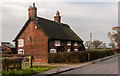
Tabley Road
House on Tabley Road near Knutsford.
Image: © Peter McDermott
Taken: 29 Nov 2014
0.00 miles
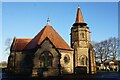
3
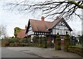
House at the Entrance of Tabley Hill Cemetery
Image: © Anthony Parkes
Taken: 5 Mar 2014
0.22 miles
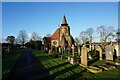
4
Knutsford Cemetery
Knutsford Cemetery at Tabley Hill.
Image: © Peter McDermott
Taken: 11 Aug 2014
0.23 miles
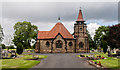
7
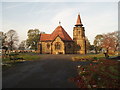
Knutsford Cemetery Tabley Hill
Knutsford Cemetery on Tabley Hill Lane was built in 1902
Image: © Ian Warburton
Taken: 19 Nov 2005
0.24 miles