IMAGES TAKEN NEAR TO
Mag Lane, KNUTSFORD, WA16 0AA
Introduction
This page details the photographs taken nearby to Mag Lane, WA16 0AA by members of the Geograph project.
The Geograph project started in 2005 with the aim of publishing, organising and preserving representative images for every square kilometre of Great Britain, Ireland and the Isle of Man.

There are currently over 7.5m images from over14,400 individuals and you can help contribute to the project by visiting https://www.geograph.org.uk
Image Map
Images are licensed for reuse under creativecommons.org/licenses/by-sa/2.0
Notes
- Clicking on the map will re-center to the selected point.
- The higher the marker number, the further away the image location is from the centre of the postcode.
Image Listing (10 Images Found)
Images are licensed for reuse under creativecommons.org/licenses/by-sa/2.0
Image
Details
Distance
1
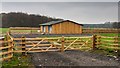
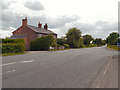
Little Oaks
New barn near Little Oaks seen from Mag Lane.
Image: © Peter McDermott
Taken: 29 Nov 2014
0.06 miles
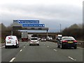
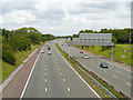
3
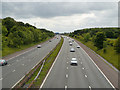
M56 (West) from Mag Lane Bridge
Looking west along the M56 from the bridge at Mag Lane.
Image: © David Dixon
Taken: 16 Jun 2013
0.19 miles

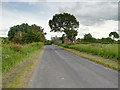
6
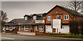
Tishon House
Tishon House on the A50.
Image: © Peter McDermott
Taken: 29 Nov 2014
0.21 miles
9
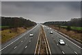
M56 Motorway
The M56 Motorway seen from Mag Lane.
Image: © Peter McDermott
Taken: 29 Nov 2014
0.24 miles
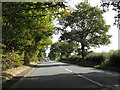
10
M56 Motorway (East)
Looking east from the bridge at Mag Lane.
Image: © David Dixon
Taken: 16 Jun 2013
0.24 miles