IMAGES TAKEN NEAR TO
Mayors Road, ALTRINCHAM, WA15 9RW
Introduction
This page details the photographs taken nearby to Mayors Road, WA15 9RW by members of the Geograph project.
The Geograph project started in 2005 with the aim of publishing, organising and preserving representative images for every square kilometre of Great Britain, Ireland and the Isle of Man.

There are currently over 7.5m images from over14,400 individuals and you can help contribute to the project by visiting https://www.geograph.org.uk
Image Map
Images are licensed for reuse under creativecommons.org/licenses/by-sa/2.0
Notes
- Clicking on the map will re-center to the selected point.
- The higher the marker number, the further away the image location is from the centre of the postcode.
Image Listing (143 Images Found)
Images are licensed for reuse under creativecommons.org/licenses/by-sa/2.0
Image
Details
Distance
1

Commemorative slab, Charter Road
Special paving slabs were laid in 1990 beside all the street lights in Charter Road, Altrincham [http://www.geograph.org.uk/photo/4540395] to commemorate the 700th anniversary of the granting of the town's charter in 1290.
Image: © Richard Sutcliffe
Taken: 19 Jun 2015
0.03 miles
2
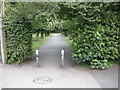
Entrance to Stamford Park, Altrincham
The footpath leading into the north west corner of Stamford Park.
Image: © Richard Sutcliffe
Taken: 19 Jun 2015
0.03 miles
3
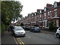
Charter Road, Altrincham
The road's name commemorates Altrincham's borough charter, which was granted in 1290.
Image: © Richard Sutcliffe
Taken: 19 Jun 2015
0.05 miles
4
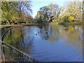
Former bathing pool
In Stamford Park
Image: © Kevin Waterhouse
Taken: 10 Nov 2023
0.07 miles
5
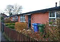
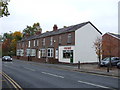
Affordable Housing
These were the first, post-war 'Prefabs' to be built in Altrincham, to relieve the acute housing shortage created by German bombing - aimed at the nearby armaments factories in Broadheath.
When first erected, in the 1940s, they consisted of naked concrete panels slotted together on site. More recently, they received brick cladding, which improved both the aesthetics and the insulation.
They were on the corner of the street leading to the then Altrincham Gas Works, and rail tracks - set into the roadway of Moss Lane - periodically carried coal wagons from Altrincham to the Works, past their front doors.
Image: © Anthony O'Neil
Taken: 25 Feb 2024
0.09 miles
6
Blessed Thomas Holford school
Urban Road, Altrincham
Image: © Anthony O'Neil
Taken: 25 Feb 2024
0.12 miles
8
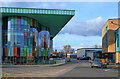
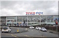
Tesco Extra, Altrincham
The Tesco Extra store at the corner of Manor Road and Moss Lane.
Image: © David Dixon
Taken: 12 Jan 2012
0.15 miles
10
"Every little helps"
On Manor Road, Altrincham
Image: © Anthony O'Neil
Taken: 4 Mar 2017
0.16 miles