IMAGES TAKEN NEAR TO
Park Road, ALTRINCHAM, WA15 9NL
Introduction
This page details the photographs taken nearby to Park Road, WA15 9NL by members of the Geograph project.
The Geograph project started in 2005 with the aim of publishing, organising and preserving representative images for every square kilometre of Great Britain, Ireland and the Isle of Man.

There are currently over 7.5m images from over14,400 individuals and you can help contribute to the project by visiting https://www.geograph.org.uk
Image Map
Images are licensed for reuse under creativecommons.org/licenses/by-sa/2.0
Notes
- Clicking on the map will re-center to the selected point.
- The higher the marker number, the further away the image location is from the centre of the postcode.
Image Listing (55 Images Found)
Images are licensed for reuse under creativecommons.org/licenses/by-sa/2.0
Image
Details
Distance
1
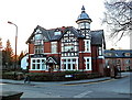
Luxury apartments, Ashley Road, Hale
Formerly the Bleeding Wolf hotel. Other accommodation was created in new-build property at the rear, alongside the Manchester/Chester railway line which runs at the back. The rather strange name for the pub is said, by some authorities, to derive from its having been on land where the last wolf in England was slain.
Image: © Anthony O'Neil
Taken: 28 Jan 2011
0.04 miles
2
Broussa Day Nursery
Highly regarded Kindergarten on Warwick Road, Hale.
The name is unusual: it is an ancient town in Asia Minor (Turkey), near to the Sea of Marmara, and once the capital, before the founding of Constantinople (Istanbul). It was famous for its mineral springs, silk manufacture and the export of Meerschaum clay.
Image: © Anthony O'Neil
Taken: 23 Feb 2023
0.04 miles
3
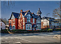
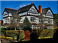
Living in Hale (2)
Wolf Grange, Ashley Road
Image: © Anthony O'Neil
Taken: 23 Feb 2023
0.04 miles
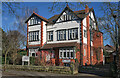
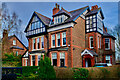
4
The former Bleeding Wolf pub
Now private accommodation.
Image: © Richard Sutcliffe
Taken: 14 Feb 2016
0.05 miles
7
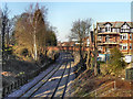
Heather Road Bridge
The bridge carrying Heather Road (B5162) over the railway at Hale.
Image: © David Dixon
Taken: 16 Jan 2012
0.07 miles
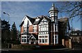
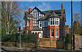
8
Large semi-detached
265 Ashley Road, Hale. Typical of properties in this area of Hale.
Image: © Anthony O'Neil
Taken: 16 Feb 2023
0.08 miles
9
United Reformed Church
Ashley Road / Cecil Road, Hale
Image: © Anthony O'Neil
Taken: 16 Feb 2023
0.08 miles
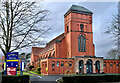
10

Altrincham United Reformed Church (Trinity Hale Church)
Situated on the corner of Cecil Road and Ashley Road in Hale, this church was opened in the early part of the twentieth century.
Image: © David Dixon
Taken: 16 Jan 2012
0.08 miles