IMAGES TAKEN NEAR TO
Park Road, ALTRINCHAM, WA15 9LE
Introduction
This page details the photographs taken nearby to Park Road, WA15 9LE by members of the Geograph project.
The Geograph project started in 2005 with the aim of publishing, organising and preserving representative images for every square kilometre of Great Britain, Ireland and the Isle of Man.

There are currently over 7.5m images from over14,400 individuals and you can help contribute to the project by visiting https://www.geograph.org.uk
Image Map
Images are licensed for reuse under creativecommons.org/licenses/by-sa/2.0
Notes
- Clicking on the map will re-center to the selected point.
- The higher the marker number, the further away the image location is from the centre of the postcode.
Image Listing (9 Images Found)
Images are licensed for reuse under creativecommons.org/licenses/by-sa/2.0
Image
Details
Distance
2
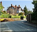
Around Hale Barns (22)
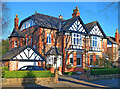
'Dragonera', Hargate Drive
Image: © Anthony O'Neil
Taken: 25 Mar 2022
0.16 miles
3
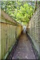
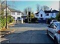
Around Hale Barns (24)
Enclosed path to Woodend Road
Image: © Anthony O'Neil
Taken: 25 Mar 2022
0.18 miles
4
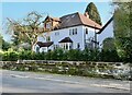
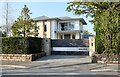
Around Hale Barns (21)
'White Gables', Hargate Drive
Image: © Anthony O'Neil
Taken: 25 Mar 2022
0.18 miles
5
Around Hale Barns (23)
'Lynn Garth', Howard Drive
Image: © Anthony O'Neil
Taken: 25 Mar 2022
0.20 miles
6
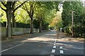
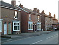
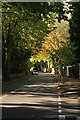
Planetree Road, Hale
Whalley Road is to the right.
Image: © Richard Sutcliffe
Taken: 8 Oct 2016
0.23 miles
7
Planetree Road, Hale
Whalley Road is to the right.
Image: © Richard Sutcliffe
Taken: 8 Oct 2016
0.23 miles